Kistler, West Virginia | |
|---|---|
 Kistler post office | |
 Kistler  Kistler | |
| Coordinates: 37°45′22″N 81°51′36″W / 37.75611°N 81.86000°W | |
| Country | United States |
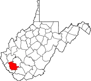
| State | West Virginia |
| County | Logan |
| Area | |
| • Total | 1.494 sq mi (3.87 km2) |
| • Land | 1.486 sq mi (3.85 km2) |
| • Water | 0.008 sq mi (0.02 km2) |
| Elevation | 774 ft (236 m) |
| Population | |
| • Total | 528 |
| • Density | 355.3/sq mi (137.2/km2) |
| Time zone | UTC-5 (Eastern (EST)) |
| • Summer (DST) | UTC-4 (EDT) |
| ZIP Code | 25628 |
| Area code(s) | 304 & 681 |
| GNIS feature ID | 1541251[3] |
| FIPS code | 54-44188 |
Kistler is an unincorporated community and census-designated place (CDP) in Logan County, West Virginia, United States. As of the 2010 census, its population was 528.[2]
Geography
Kistler is in southern Logan County, 1.5 miles (2.4 km) northeast of Man, along Buffalo Creek.[4] It is bordered to the northeast (upstream) by Accoville.
According to the U.S. Census Bureau, the Kistler CDP has a total area of 1.494 square miles (3.87 km2), of which 1.486 square miles (3.85 km2) are land and 0.008 square miles (0.021 km2), or 0.54%, are water.[1] The community was affected by the Buffalo Creek flood in 1972.
References
- 1 2 "2020 U.S. Gazetteer Files – West Virginia". United States Census Bureau. Retrieved March 15, 2021.
- 1 2 "Total Population: 2010 Census DEC Summary File 1 (P1), Kistler CDP, West Virginia". data.census.gov. U.S. Census Bureau. Retrieved March 15, 2021.
- ↑ U.S. Geological Survey Geographic Names Information System: Kistler, West Virginia
- ↑ West Virginia Atlas & Gazetteer. Yarmouth, Me.: DeLorme. 1997. p. 57. ISBN 0-89933-246-3.
This article is issued from Wikipedia. The text is licensed under Creative Commons - Attribution - Sharealike. Additional terms may apply for the media files.