Knoxlyn, Pennsylvania | |
|---|---|
 Knoxlyn  Knoxlyn | |
| Coordinates: 39°49′51″N 77°19′01″W / 39.83083°N 77.31694°W | |
| Country | United States |
| State | Pennsylvania |
| County | Adams |
| Elevation | 541 ft (165 m) |
| Time zone | UTC-5 (Eastern (EST)) |
| • Summer (DST) | UTC-4 (EDT) |
| Area code(s) | 717 & 223 |
| GNIS feature ID | 1203958[1] |
Knoxlyn is an unincorporated community situated in Highland Township in Adams County, Pennsylvania, United States.[1] It is located 8 kilometers (5.0 mi) west of Gettysburg between U.S. Route 30 and Pennsylvania Route 116.[2]
References
- 1 2 "Knoxlyn". Geographic Names Information System. United States Geological Survey, United States Department of the Interior.
- ↑ General Highway Map: Adams County, Pennsylvania (PDF) (Map). Pennsylvania Department of Transportation. 2018. Retrieved March 11, 2019.
Municipalities and communities of Adams County, Pennsylvania, United States | ||
|---|---|---|
| Boroughs | 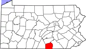 | |
| Townships | ||
| CDPs | ||
| Unincorporated communities | ||
| Ghost town | ||
This article is issued from Wikipedia. The text is licensed under Creative Commons - Attribution - Sharealike. Additional terms may apply for the media files.