Koun-Fao Department
Département de Koun-Fao | |
|---|---|
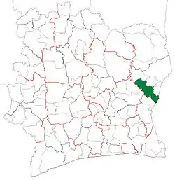 Location in Ivory Coast. Koun-Fao Department has retained the same boundaries since its creation in 2005. | |
| Country | |
| District | Zanzan |
| Region | Gontougo |
| 2005 | Established as a second-level subdivision via a division of Tanda Dept |
| 2011 | Converted to a third-level subdivision |
| Departmental seat | Koun-Fao |
| Government | |
| • Prefect | Yolande Djirabou |
| Area | |
| • Total | 3,600 km2 (1,400 sq mi) |
| Population (2021 census)[1] | |
| • Total | 167,881 |
| • Density | 47/km2 (120/sq mi) |
| Time zone | UTC+0 (GMT) |
Koun-Fao Department is a department of Gontougo Region in Zanzan District, Ivory Coast. In 2021, its population was 167,881 and its seat is the settlement of Koun-Fao. The sub-prefectures of the department are Boahia, Kokomian, Kouassi-Datékro, Koun-Fao, Tankessé, and Tienkoikro.
History
Koun-Fao Department was created in 2005 as a second-level subdivision via a split-off from Tanda Department.[2] At its creation, it was part of Zanzan Region.
In 2011, districts were introduced as new first-level subdivisions of Ivory Coast. At the same time, regions were reorganised and became second-level subdivisions and all departments were converted into third-level subdivisions. At this time, Koun-Fao Department became part of Gontougo Region in Zanzan District.
Notes
- ↑ Citypopulation.de Population of the regions and departments of Ivory Coast
- ↑ "Regions of Côte d'Ivoire (Ivory Coast)", statoids.com, accessed 16 February 2016.
.svg.png.webp)
Regional seat: Bondoukou | ||
| Bondoukou Department | 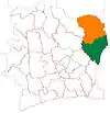 | |
| Koun-Fao Department | ||
| Sandégué Department | ||
| Tanda Department | ||
| Transua Department | ||
* also a commune | ||
7°29′N 3°15′W / 7.483°N 3.250°W