Kushla, Alabama | |
|---|---|
 Kushla  Kushla | |
| Coordinates: 30°48′56″N 088°09′29″W / 30.81556°N 88.15806°W [1] | |
| Country | United States |
| State | Alabama |
| County | Mobile |
| Elevation | 62 ft (19 m) |
| Time zone | UTC-6 (Central (CST)) |
| • Summer (DST) | UTC-5 (CDT) |
| Area code | 251 |
| GNIS ID[1] | 121285 |
Kushla is an unincorporated community in Mobile County, Alabama, United States.[1][2] A post office operated under the name Kushla from 1887 to 1919.[3] The community's name is likely derived from the Choctaw words kusha meaning "cane" and hieli meaning "standing".[4]
Geography
Kushla is located at 30°48′56″N 088°09′29″W / 30.81556°N 88.15806°W. The elevation is 62 feet (19 m).[1][2]
References
- 1 2 3 4 5 "Feature Detail Report for: Kushla (Mobile County, Alabama)". Geographic Names Information System. United States Geological Survey, United States Department of the Interior. Retrieved January 8, 2013.
- 1 2 "Kushla, Alabama". Alabama Home Town Locator. Retrieved March 9, 2008.
- ↑ "Mobile County". Jim Forte Postal History. Retrieved March 3, 2015.
- ↑ Read, William A. (1984). Indian Place Names in Alabama. Tuscaloosa: The University of Alabama Press. p. 39. ISBN 0-8173-0231-X.
Municipalities and communities of Mobile County, Alabama, United States | ||
|---|---|---|
| Cities | 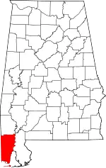 Map of Alabama highlighting Mobile County | |
| Towns | ||
| CDPs | ||
| Unincorporated communities | ||
| Ghost town | ||
| Indian reservation | ||
| Footnotes | ‡This populated place also has portions in an adjacent county or counties | |
This article is issued from Wikipedia. The text is licensed under Creative Commons - Attribution - Sharealike. Additional terms may apply for the media files.