| Lac de Nino | |
|---|---|
 | |
 Lac de Nino | |
| Location | Haute-Corse |
| Coordinates | 42°15′20″N 8°56′25″E / 42.25556°N 8.94028°E |
| Type | glacial |
| Primary outflows | Tavignano |
| Basin countries | France |
| Surface area | 0.065 km2 (0.025 sq mi) |
| Max. depth | 12 m (39 ft) |
| Surface elevation | 1,743 m (5,719 ft) |
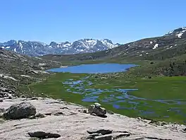
Lac de Nino is a lake in Haute-Corse, France. At an elevation of 1743 m, its surface area is 0.065 km².
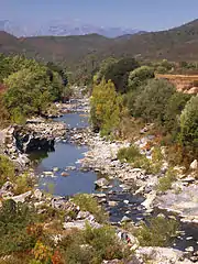
The lake is on the Tavignano river near to its source below the 1,883 metres (6,178 ft) Bocca a Reta. It is on the boundary between the communes of Casamaccioli and Corte. The river flows through marshy land above and below the lake.[1]
References
Sources
- "Way: Lac de Nino (28890021)", OpenStreetMap, retrieved 2021-12-18
| Waterbodies |
| ||||||||||||||||||||
|---|---|---|---|---|---|---|---|---|---|---|---|---|---|---|---|---|---|---|---|---|---|
| Rivers and streams |
| ||||||||||||||||||||
| |||||||||||||||||||||
This article is issued from Wikipedia. The text is licensed under Creative Commons - Attribution - Sharealike. Additional terms may apply for the media files.