Lafage-sur-Sombre | |
|---|---|
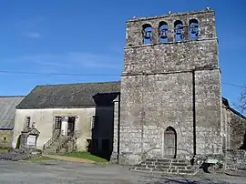 The church and presbytery in Lafage-sur-Sombre | |
.svg.png.webp) Coat of arms | |
Location of Lafage-sur-Sombre | |
 Lafage-sur-Sombre  Lafage-sur-Sombre | |
| Coordinates: 45°17′47″N 2°04′19″E / 45.2964°N 2.0719°E | |
| Country | France |
| Region | Nouvelle-Aquitaine |
| Department | Corrèze |
| Arrondissement | Ussel |
| Canton | Égletons |
| Government | |
| • Mayor (2020–2026) | Dominique Verbrugge[1] |
| Area 1 | 18.94 km2 (7.31 sq mi) |
| Population | 134 |
| • Density | 7.1/km2 (18/sq mi) |
| Time zone | UTC+01:00 (CET) |
| • Summer (DST) | UTC+02:00 (CEST) |
| INSEE/Postal code | 19097 /19320 |
| Elevation | 493–686 m (1,617–2,251 ft) |
| 1 French Land Register data, which excludes lakes, ponds, glaciers > 1 km2 (0.386 sq mi or 247 acres) and river estuaries. | |
Lafage-sur-Sombre (French pronunciation: [lafaʒ syʁ sɔ̃bʁ]; Occitan: La Faja) is a commune in the Corrèze department in central France.
Population
| Year | Pop. | ±% |
|---|---|---|
| 1962 | 139 | — |
| 1968 | 207 | +48.9% |
| 1975 | 158 | −23.7% |
| 1982 | 162 | +2.5% |
| 1990 | 159 | −1.9% |
| 1999 | 116 | −27.0% |
| 2008 | 119 | +2.6% |
See also
References
- ↑ "Répertoire national des élus: les maires". data.gouv.fr, Plateforme ouverte des données publiques françaises (in French). 2 December 2020.
- ↑ "Populations légales 2021". The National Institute of Statistics and Economic Studies. 28 December 2023.
Wikimedia Commons has media related to Lafage-sur-Sombre.
This article is issued from Wikipedia. The text is licensed under Creative Commons - Attribution - Sharealike. Additional terms may apply for the media files.