| Laute | |
|---|---|
 | |
| Location | |
| Country | Germany |
| State | Lower Saxony |
| Location | Upper Harz |
| Physical characteristics | |
| Source | |
| • location | near Hahnenklee |
| • elevation | ca. 540 m above sea level (NN) |
| Mouth | |
• location | in Lautenthal into the Innerste |
• coordinates | 51°52′11″N 10°17′06″E / 51.8698°N 10.2851°E |
• elevation | 300 m above sea level (NN) |
| Length | 6 km (3.7 mi) |
| Basin features | |
| Progression | Innerste→ Leine→ Aller→ Weser→ North Sea |
Laute is a river of Lower Saxony, Germany. It is a right tributary of the Innerste.
The Laute rises in the vicinity of Hahnenklee in the Upper Harz and discharges about 6 km (3.7 mi) later into the Innerste in Lautenthal. The source is at an elevation of about 540 m at the bottom of a mountain called Kuttelbacher Berg. The Laute flows to the west parallel to road L 516 which is called Hahnenkleer Straße in Lautenthal. The name of the town means Laute Valley. The mouth is at an elevation of about 300 m in the west of Wildemanner Strasse, the high street of Lautenthal.
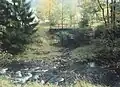
In 1875 a railway bridge of the Innerste Valley Railway was built over the Laute close to its mouth.[1] Although the railway line was closed in 1977, the bridge is well preserved and still used by hikers. A flood of the Laute caused considerable damage in Lautenthal in 1877.[2]
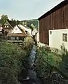 Laute in the east of Lautenthal
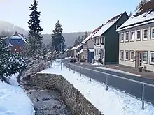 Laute in the middle of Lautenthal
- Former railway bridge over the Laute which discharges into the Innerste (in the foreground)