| Lignon du Forez | |
|---|---|
 Lignon du Forez | |
 | |
| Location | |
| Country | France |
| Physical characteristics | |
| Source | |
| • location | Chalmazel |
| • coordinates | 45°39′56″N 03°47′58″E / 45.66556°N 3.79944°E |
| • elevation | 1,490 m (4,890 ft) |
| Mouth | |
• location | Loire |
• coordinates | 45°45′29″N 04°11′40″E / 45.75806°N 4.19444°E |
• elevation | 320 m (1,050 ft) |
| Length | 58.9 km (36.6 mi) |
| Basin size | 664 km2 (256 sq mi) |
| Discharge | |
| • average | 8.33 m3/s (294 cu ft/s) |
| Basin features | |
| Progression | Loire→ Atlantic Ocean |
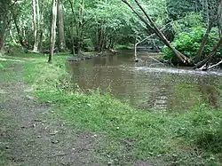
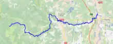
The Lignon du Forez (French pronunciation: [liɲɔ̃ dy fɔʁɛ], literally Lignon of the Forez; also called Lignon de Chalmazel, literally Lignon of Chalmazel) is a 58.9 km (36.6 mi) long river in the Loire department, east-central France.[1] Its source is near Chalmazel. It flows generally east. It is a left tributary of the Loire into which it flows near Feurs.
Communes along its course
This list is ordered from source to mouth:
Chalmazel, Jeansagnière, Sauvain, Saint-Bonnet-le-Courreau, Saint-Georges-en-Couzan, Sail-sous-Couzan, Saint-Sixte, Leigneux, Boën, Trelins, Marcoux, Sainte-Agathe-la-Bouteresse, Montverdun, Saint-Étienne-le-Molard, Poncins, Cleppé, Feurs
References
This article is issued from Wikipedia. The text is licensed under Creative Commons - Attribution - Sharealike. Additional terms may apply for the media files.