| European routes in the Netherlands | |
|---|---|
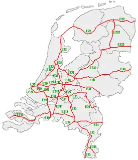 European routes in the Netherlands highlighted in red | |
| System information | |
| Maintained by Rijkswaterstaat[1] | |
| Highway names | |
| European routes: | European route E nn (E nn) |
| System links | |

E-road marker on Dutch road sign
This is a list of the European Routes, or E-road highways, that run through the Netherlands. The current network is signposted according to the 1985 system revision, and contains seven Class A roads and six Class B roads within the country. Almost without exception, these are motorways that also carry various national A-numbers (for Autosnelweg). Only two small stretches of the E25 and the E30 are provincial roads (the N220 and N211 respectively).[2]
Description
History
The original E-road numbering of 1957 included ten routes, but was supplanted by the 1985 revision.[3]
Class-A European routes
| Number | Length (km)[4] | Length (mi) | Southern or western terminus | Northern or eastern terminus | Formed | Removed | Notes | |
|---|---|---|---|---|---|---|---|---|
| 140 | 87 | Amsterdam | Belgian border in Breda | — | — | Follows A10, A4, A13, A20, A16, A59, and A58 | ||
| 260 | 160 | Amsterdam[5] | German border at Bad Nieuweschans | — | — | Follows A10, N7 and A7 | ||
| 275 | 171 | Hook of Holland | Belgian border near Eijsden | — | — | Follows N220, A20, A12, and A2 | ||
| 230 | 140 | Ferry service at Hook of Holland | German border near De Lutte | — | — | Follows N211, A4, A12, A27, A28, and A1 | ||
| 135 | 84 | Ridderkerk | German border in Gennep | — | — | Follows A15, A73 and A77 | ||
| 80 | 50 | Belgian border in Bladel | German border in Venlo | — | — | Follows A67 | ||
| 130 | 81 | Amsterdam | German border at Zevenaar | — | — | Follows A10, A2 and A12; original route to Groningen now E231 and E232 | ||
- Class-A European routes


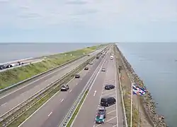 E 22 on the Afsluitdijk
Class-B European routes
| Number | Length (km)[6] | Length (mi) | Southern or western terminus | Northern or eastern terminus | Formed | Removed | Notes | |
|---|---|---|---|---|---|---|---|---|
| 40 | 25 | Amsterdam | Amersfoort | 1987 | current | Was E35 from 1950-1975 and E230 from 1975-1987; follows A1 | ||
| 180 | 110 | Amersfoort | Groningen | 1987 | current | Was E35 from 1950-1975 and E231 from 1975-1987; follows A28 | ||
| 45 | 28 | Hoogeveen | German border in Emmen | 1987 | current | Was E232 before 1987; originally ran from Oldenzaal to the German border until 1994; follows A37 | ||
| 65 | 40 | Breda | Utrecht | 1987 | current | Was E37 until 1987; follows A27 | ||
| 155 | 96 | Vlissingen | Eindhoven | 1987 | current | Section from Breda to Eindhoven was E38 and Vlissingen to Breda was N97 before 1987; follows A58 | ||
| 35 | 22 | Belgian border in Stein | German border in Simpelveld | — | — | Follows A76 | ||
- Class-B European routes
 E 314 and E 25 at the Kerensheide interchange
See also
References
- ↑ "Wat voor wegen zijn er in Nederland en wie is de wegbeheerder". De Rijksoverheid. Archived from the original on 15 March 2014. Retrieved 21 December 2014.
- ↑ nl:Lijst van E-wegen door Nederland
- ↑ Elsevier Atlas van Nederland, België en Luxemburg, samengesteld door de Winkler Prins redactie, Amsterdam/Brussel 1960.
- ↑ Shell Stratenboek van Nederland. Editie 55 (2008); only the sections within the Netherlands are given here.
- ↑ The E22 officially connects from Britain to the Netherlands, but no ferry connection exists at this moment.
- ↑ Shell Stratenboek van Nederland. Editie 55 (2008); only the sections within the Netherlands are given here.
External links
Wikimedia Commons has media related to European roads in the Netherlands.
This article is issued from Wikipedia. The text is licensed under Creative Commons - Attribution - Sharealike. Additional terms may apply for the media files.