This list is of the Natural Monuments of Japan within the Prefecture of Nagasaki.[1]
National Natural Monuments
As of 1 April 2021, thirty-five Natural Monuments have been designated.[2][3][4]


.jpg.webp)


Prefectural Natural Monuments
As of 26 February 2021, one hundred and five Natural Monuments have been designated at a prefectural level.[4][5]
| Monument | Municipality | Comments | Image | Coordinates | Type | Ref. |
|---|---|---|---|---|---|---|
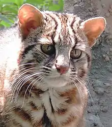
| Deer of Hirado 平戸のシカ Hirado no shika | Hirado | on Mount Yasumandake (安満岳) |  | 33°20′06″N 129°28′09″E / 33.335039°N 129.469159°E | ||
| Biryō-jima 美良島 Biryō-jima | Ojika | 33°10′06″N 128°54′00″E / 33.168195°N 128.899933°E | ||||
Municipal Natural Monuments
As of 1 May 2020, one hundred and thirty-eight Natural Monuments have been designated at a municipal level.[6]
| Hokkaidō |   | |
|---|---|---|
| Tōhoku |
| |
| Kantō |
| |
| Chūbu |
| |
| Kansai |
| |
| Chūgoku |
| |
| Shikoku | ||
| Kyūshū | ||
| Okinawa | ||
1 | ||
See also
- Cultural Properties of Japan
- Parks and gardens in Nagasaki Prefecture
- List of Places of Scenic Beauty of Japan (Nagasaki)
- List of Historic Sites of Japan (Nagasaki)
References
- ↑ "Cultural Properties for Future Generations". Agency for Cultural Affairs. Retrieved 8 April 2021.
- ↑ 史跡名勝天然記念物 [Number of Monuments by Prefecture] (in Japanese). Agency for Cultural Affairs. 1 April 2021. Retrieved 8 April 2021.
- ↑ "Database of National Cultural Properties: 史跡名勝天然記念物 (天然記念物, 特別天然記念物 長崎県 定めず)" (in Japanese). Agency for Cultural Affairs. Retrieved 8 April 2021.
- 1 2 文化財件数一覧 [Number of Cultural Properties] (in Japanese). Nagasaki Prefecture. 26 February 2021. Retrieved 8 April 2021.
- ↑ 都道府県別指定等文化財件数(都道府県分) [Number of Prefectural Cultural Properties by Prefecture] (in Japanese). Agency for Cultural Affairs. 1 May 2020. Retrieved 8 April 2021.
- ↑ 都道府県別指定等文化財件数(市町村分) [Number of Municipal Cultural Properties by Prefecture] (in Japanese). Agency for Cultural Affairs. 1 May 2020. Retrieved 8 April 2021.
External links
- (in Japanese) Cultural Properties in Nagasaki Prefecture
This article is issued from Wikipedia. The text is licensed under Creative Commons - Attribution - Sharealike. Additional terms may apply for the media files.