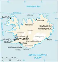
Map of Iceland
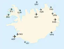
Map of Iceland with public airports
This is a list of airports in Iceland. There are no railways in Iceland. Driving from Reykjavík to Akureyri takes 4–5 hours compared to 45 minutes flight time, driving from Reykjavík to Egilsstaðir takes 9 hours compared to 1 hour flight time.[1]
Airports
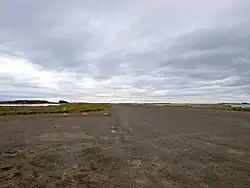
The landing strip of Djúpivogur Airport.
Airport names shown in bold have scheduled passenger service on commercial airlines.
Not listed are former military airports and airbases Naval Air Station Keflavik (which is now Keflavik International Airport), RAF Reykjavik (which is now Reykjavik Airport) and RAF Kaldadarnes (which is now abandoned). Also not listed are smaller airfields like Sandskeið glider airfield.
See also
- Transport in Iceland
- List of airports by ICAO code: B#BI - Iceland
- Wikipedia: Airline destination lists: Europe#Iceland
- List of the largest airports in the Nordic countries
References
- "ICAO Location Indicators by State" (PDF). International Civil Aviation Organization. 17 September 2010.
- "IATA Airline and Airport Code Search". International Air Transport Association.
- "UN Location Codes: Iceland". UN/LOCODE 2012-1. UNECE. 14 September 2012. – includes IATA codes
- "Airports in Iceland". World Aero Data. Archived from the original on February 17, 2013.
{{cite web}}: CS1 maint: unfit URL (link) – ICAO codes and airport data - "Airports in Iceland". Great Circle Mapper. – IATA and ICAO codes
This article is issued from Wikipedia. The text is licensed under Creative Commons - Attribution - Sharealike. Additional terms may apply for the media files.