Map of Uruguay

This is a list of airports in Uruguay, sorted alphabetically by ICAO code.

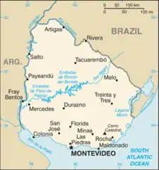
Uruguay, officially known as the Oriental Republic of Uruguay (Spanish: República Oriental del Uruguay), is a country located in the southeastern part of South America. Uruguay's only land border is with Brazil, to the north. To the west lies the Uruguay River, to the southwest lies the estuary of Río de la Plata, with Argentina only a short commute across the banks of either of these bodies of water, while to the southeast lies the South Atlantic Ocean. Uruguay is the second smallest country in South America, being larger only than Suriname.

Airport

Airport names shown in bold indicate the airport has scheduled service on commercial airlines.

Airport name IATA code ICAO code City served Department Coordinates
Ángel Adami International AirportSUAAMontevideo Montevideo34°47′21″S 56°15′53″W / 34.78917°S 56.26472°W / -34.78917; -56.26472
Artigas International AirportATISUAGArtigas Artigas30°23′57″S 56°30′39″W / 30.39917°S 56.51083°W / -30.39917; -56.51083
Estancia Presidencial Anchorena AirportSUANBarra de San Juan Colonia34°16′13″S 57°57′51″W / 34.27028°S 57.96417°W / -34.27028; -57.96417
Cap. Juan Manuel Boiso Lanza Air BaseSUBLMontevideo Montevideo34°48′40″S 56°09′50″W / 34.81111°S 56.16389°W / -34.81111; -56.16389
Placeres AirportBUVSUBUBella Unión Artigas30°19′10″S 57°33′33″W / 30.31944°S 57.55917°W / -30.31944; -57.55917
Laguna de los Patos International AirportCYRSUCAColonia del Sacramento Colonia34°27′05″S 57°46′01″W / 34.45139°S 57.76694°W / -34.45139; -57.76694
Zagarzazú International AirportSUCMCarmelo Colonia33°57′58″S 58°19′31″W / 33.96611°S 58.32528°W / -33.96611; -58.32528
Santa Bernardina International AirportDZOSUDUDurazno Durazno33°21′23″S 56°29′46″W / 33.35639°S 56.49611°W / -33.35639; -56.49611
Villa Independencia AirportSUFBFray Bentos Río Negro33°08′35″S 58°17′38″W / 33.14306°S 58.29389°W / -33.14306; -58.29389
C/C Carlos A. Curbelo de Laguna del Sauce International AirportPDPSULSMaldonado and Punta del Este Maldonado34°51′30″S 55°05′30″W / 34.85833°S 55.09167°W / -34.85833; -55.09167
Ricardo Detomasi AirportSUMEMercedes Soriano33°14′55″S 58°04′22″W / 33.24861°S 58.07278°W / -33.24861; -58.07278
Campo Municipal de Aterrizaje AirportSUMIMinas Lavalleja34°20′43″S 55°13′37″W / 34.34528°S 55.22694°W / -34.34528; -55.22694
Cerro Largo International AirportMLZSUMOMelo Cerro Largo32°20′33″S 54°13′19″W / 32.34250°S 54.22194°W / -32.34250; -54.22194
Carrasco Gral. Cesáreo L. Berisso International AirportMVDSUMUMontevideo Canelones34°50′02″S 56°01′41″W / 34.83389°S 56.02806°W / -34.83389; -56.02806
El Jagüel AirportSUPEMaldonado and Punta del Este Maldonado34°54′47″S 54°55′09″W / 34.91306°S 54.91917°W / -34.91306; -54.91917
Tydeo Larre Borges International AirportPDUSUPUPaysandú Paysandú32°21′47″S 58°03′59″W / 32.36306°S 58.06639°W / -32.36306; -58.06639
Río Branco AirportSURBRío Branco Cerro Largo32°34′54″S 53°27′14″W / 32.58167°S 53.45389°W / -32.58167; -53.45389
Pte. Gral. Óscar D. Gestido International AirportRVYSURVRivera and Santana do Livramentoa Rivera30°58′10″S 55°28′24″W / 30.96944°S 55.47333°W / -30.96944; -55.47333
Nueva Hespérides International AirportSTYSUSOSalto Salto31°26′05″S 57°59′03″W / 31.43472°S 57.98417°W / -31.43472; -57.98417
Tacuarembó AirportTAWSUTBTacuarembó Tacuarembó31°45′01″S 55°55′26″W / 31.75028°S 55.92389°W / -31.75028; -55.92389
Treinta y Tres AirportTYTSUTRTreinta y Tres Treinta y Tres33°11′42″S 54°20′50″W / 33.19500°S 54.34722°W / -33.19500; -54.34722
Vichadero AirportVCHSUVOVichadero Rivera31°44′21″S 54°35′16″W / 31.73917°S 54.58778°W / -31.73917; -54.58778

Note:
a: Since August 14, 2023, SURV is a special case being a binational facility, serving both Uruguay and Brazil.[1][2]

See also

References

  1. "Uruguay y Brasil declararon binacional al aeropuerto de Rivera". Uruguay Presidencia (in Spanish). 14 August 2023. Retrieved 17 August 2023.
  2. "Brasil e Uruguai acordam uso compartilhado do aeroporto de Rivera". Agência Brasil (in Portuguese). 14 August 2023. Retrieved 14 August 2023.

Media related to Airports in Uruguay at Wikimedia Commons

This article is issued from Wikipedia. The text is licensed under Creative Commons - Attribution - Sharealike. Additional terms may apply for the media files.