According to the Pakistan Environmental Protection Agency's report published on protected areas in 1997, Balochistan has 27 archaeological sites and monuments protected by the Federal Government.[1] These include the province's only national monument; Ziarat Residency. Additionally it has one site on the tentative world heritage list, Mehrgarh.[2]
Of the some 400 sites and monuments protected under the Antiquities Act 1975, the province contains seven sites in Category 1, eight in Category II and fourteen in Category III.[3]
National monuments, UNESCO inscribed and tentative sites
Federal Government
The following sites were previously protected under the Federal Government.
| ID | Name | Type | Location | District | Coordinates | Image |
|---|---|---|---|---|---|---|
| BA-1 | Pirak mound | Village Kolachi — located 17 kilometres (11 mi) south of Sibi on the right side of the road to Jacobabad[4] | Sibi District | |||
| BA-2 | Nindo Damb | Ornach Valley, Tehsil Wadh | Killa Abdullah District |  Tunnel, Chaman&categories= Upload Photo | ||
| BA-3 | Fort wall of Jhalawar | Jhalawar | Kharan District | Upload Photo | ||
| BA-4 | Fort of Azad Khan (Kharan Fort) | Kharan town | Kharan | 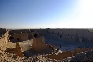 Fort of Azad Khan (Kharan Fort) | ||
| BA-5 | Pally Kalat | Washbohi | Kharan |  Pally Kalat | ||
| BA-6 | Nauroze Fort | Nauroze | Kharan | Upload Photo | ||
| BA-7 | Ancient tomb | Jhalawar | Kharan |  Ancient tomb | ||
| BA-8 | Har-o-Goke | Garuk | Kharan | Upload Photo | ||
| BA-9 | Bara Bagh Cemetery, Lasbela | Babrs | Lasbela District | |||
| BA-10 | Tomb of General Muhammad Ibn-e-Haroon | Bela town | Lasbela | Upload Photo | ||
| BA-11 | Tombs at Hinidan | Pir Mubarakm | Lasbela |  Tombs at Hinidan | ||
| BA-12 | Chowkhundi (Rumi) graves | Bhawani Sarai, 5 miles from Hub Chowki | Lasbela | |||
| BA-13 | Tordheri site | Tordheri | Loralai District | Upload Photo | ||
| BA-14 | High mound | Dabarkot | Loralai | Upload Photo | ||
| BA-15 | Prehistoric mound | Harian Haider Zai | Loralai |  Prehistoric mound | ||
| BA-16 | Damb Judeir or Judeir-jo-daro | Deh Jodher No. 2 between Jhat Pat and Dera Murad Jamali | Nasirabad District | Upload Photo | ||
| BA-17 | Mound No. 1 in Killi Gul Muhammad | Village Kotwal — located 3 kilometres (1.9 mi) northwest of Quetta city on the left side of the road to Chaman[4] | Quetta District | Upload Photo | ||
| BA-18 | Mound No. 2 | Village Samangali, west side of Airport | Quetta | Upload Photo | ||
| BA-19 | Mound No. 3 in Damb Sadat | Located 13 kilometres (8.1 mi)southwest from Quetta city[4] | Quetta | Upload Photo | ||
| BA-20 | Mound No. 5 in Ahmad Khanzai | Located 5 kilometres (3.1 mi) south of Quetta[4] | Quetta | Upload Photo | ||
| BA-21 | Mound No. 6 | Shahi Khan, near Pir Ballo on Sariab Road | Quetta | Upload Photo | ||
| BA-22 | Mound No. 7 | Kachlak on Chaman Road | Quetta | Upload Photo | ||
| BA-23 | Mound No. 8 | Village Samali (Dosak-i-Khasyan) | Quetta | Upload Photo | ||
| BA-24 | Mound No. 9 | Village Metar Zai | Quetta | Upload Photo | ||
| BA-25 | Mound No. 10 | Shaikh Manda on Chaman Road | Quetta |  Mound No. 10 | ||
| BA-26 | Mound No. 11 | Village Vauhisar | Quetta | Upload Photo | ||
| BA-27 | Quaid-i-Azam Residency Building | Ziarat | Ziarat District |  Quaid-i-Azam Residency Building | ||
| BA-28 | Archaeological Site of Mehrgarh | Dhadar - located 18 kilometres (11 mi) southeast of Dhadar Town on the right bank of Bolan River[4] | Bolan District | 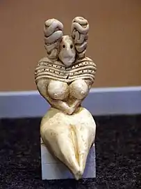 Archaeological Site of Mehrgarh |


_graves.jpg.webp)
Unprotected sites and heritage
| ID | Name | Type | Location | District | Coordinates | Image |
|---|---|---|---|---|---|---|
| BA-U-1 | Bangi Ismail’s tomb (1468) | [5] | Gwadar | Upload Photo | ||
| BA-U-2 | Jiwani graves c1400 AD | Jiwani[5] | Gwadar |  Jiwani graves c1400 AD | ||
| BA-U-3 | Pasni graves c1400 AD | Pasni[5] | Gwadar | Upload Photo | ||
| BA-U-4 | Sohbatpur Mosque (1940) | [5] | Jaffarabad | Upload Photo | ||
| BA-U-5 | Kalatuk (Fort) c 1700 AD | [5] | Kech |  Kalatuk (Fort) c 1700 AD | ||
| BA-U-6 | Miri Qila (Miri Fort) | [5] | Kech | .jpg.webp) Miri Qila (Miri Fort) | ||
| BA-U-7 | Nikoderian Tombs | in Mashkel, Nag and Panjgur[5] | Kharan & Panjgur | Upload Photo | ||
| BA-U-8 | Khawaja Amran Shrine | Near Gulistan[6] | Killa Abdullah | Upload Photo | ||
| BA-U-9 | Spin Ghundi Mound | Close to Habibzai Village at the foot of an offshoot of the Khawaja Amran Range[6] | Killa Abdullah | Upload Photo | ||
| BA-U-10 | Gondrani (or Gundriani) | [7] | Lasbela |  Gondrani (or Gundriani) | ||
| BA-U-11 | Shah Bilawal's Shrine | [8] | Khuzdar |  Shah Bilawal's Shrine | ||
| BA-U-12 | Jamia Mosque c1838 | Bela[5] | Lasbela | Upload Photo | ||
| BA-U-13 | Lahut-i-Lamakan (cave) | [8] | Khuzdar |  Lahut-i-Lamakan (cave) | ||
| BA-U-14 | Kumb Shrine | [8] | Lasbela | Upload Photo | ||
| BA-U-15 | Shireen and Farhad (shrine) | [8] | Lasbela |  Shireen and Farhad (shrine) | ||
| BA-U-16 | Sassi and Punnu (shrine) | Mouza Mumbar, Tehsil Sonmiani[9] | Lasbela | Upload Photo | ||
| BA-U-17 | Pir Fida Hussain's shrine | [8] | Lasbela | Upload Photo | ||
| BA-U-18 | Pir Moosiani's shrine | [8] | Lasbela | Upload Photo | ||
| BA-U-19 | Pir Mohiddin's shrine | [8] | Lasbela | Upload Photo | ||
| BA-U-20 | Mai Gondrani's shrine | [8] | Lasbela | Upload Photo | ||
| BA-U-21 | Shahi Jamia Mosque | Bela[9] | Lasbela | Upload Photo | ||
| BA-U-22 | Sir Robert Sandeman's tomb | Bela[9] | Lasbela | Upload Photo | ||
| BA-U-23 | Karia Pir's shrine | Bela[9] | Lasbela | Upload Photo | ||
| BA-U-24 | Sassi's spring | [9] | Lasbela | Upload Photo | ||
| BA-U-25 | Chinjan | 68 km southwest of Loralai[10] | Loralai | .jpg.webp) Chinjan | ||
| BA-U-26 | Daber Kot | 18km northeast of Duki Town[10] | Loralai | Upload Photo | ||
| BA-U-27 | Mughal Qila (Mughal Fort) – c 1500AD | [5] | Loralai | .jpg.webp) Mughal Qila (Mughal Fort) – c 1500AD | ||
| BA-U-28 | Rana Ghundai | [10] | Loralai | .jpg.webp) Rana Ghundai | ||
| BA-U-29 | Surjangal | 8km northeast of Sinjawi Town, Baghave Valley on road to Duki.[10] | Loralai |  Surjangal | ||
| BA-U-30 | Torghar — caves and rock shelters with paintings | Sulaiman Range[7] | Musakhel | Upload Photo | ||
| BA-U-31 | Zuncari Village — rock shelters | Sulaiman Range[7] | Musakhel | .png.webp) Zuncari Village — rock shelters | ||
| BA-U-32 | Sara Qila (Sara Fort) | [5] | Pishin | Upload Photo | ||
| BA-U-33 | Governor's House | [11] | Quetta | |||
| BA-U-34 | Balochistan Secretariate building | Quetta[11] | Quetta | Upload Photo | ||
| BA-U-35 | Quetta railway station | Quetta[11] | Quetta | |||
| BA-U-36 | General Post Office and Central Telegraph Office building | Quetta[11] | Quetta | Upload Photo | ||
| BA-U-37 | Sessions Courts building | Quetta[11] | Quetta |  Sessions Courts building | ||
| BA-U-38 | Balochistan High Court building | Quetta[11] | Quetta |  Balochistan High Court building | ||
| BA-U-39 | Frontier Corps Headquarters | Quetta[12] | Quetta | Upload Photo | ||
| BA-U-40 | Pakistan Command and Staff College (main building) | Quetta[12] | Quetta |  Pakistan Command and Staff College (main building) | ||
| BA-U-41 | Babar/Khosti - 10 rock shelters | Sulaiman Range[7] | Zhob | Upload Photo | ||
| BA-U-42 | Badanzai | Bronze Age[10] | Zhob | Upload Photo | ||
| BA-U-43 | Dhana Abdullahzai - 1 rock shelter - 1st time with wild boar | Sulaiman Range[7] | Zhob | Upload Photo | ||
| BA-U-44 | Hazrat Nazar Nika's Shrine | 6 km from Zhob[13] | Zhob | Upload Photo | ||
| BA-U-45 | Hazrat Khostu Baba's shrine | 100 km from Zhob towards Waziristan[13] | Zhob | Upload Photo | ||
| BA-U-46 | Ismailzai | [10] | Zhob | Upload Photo | ||
| BA-U-47 | Lakaha Band - 4 rock shelters | Sulaiman Range[7] | Zhob | Upload Photo | ||
| BA-U-48 | Leaoha Ghozai - 5 caves and 6 rock shelters | Sulaiman Range[7] | Zhob | Upload Photo | ||
| BA-U-49 | Mughal Ghundai | [10] | Zhob | Upload Photo | ||
| BA-U-50 | Musazai | [10] | Zhob | Upload Photo | ||
| BA-U-51 | Palwan Baba's shrine | Mughalkot area[13] | Zhob | Upload Photo | ||
| BA-U-52 | Paryan-o-Ghundi (or Periano Ghundai) (destroyed) | 2 miles west of Zhob[14][10] | Zhob | Upload Photo | ||
| BA-U-53 | Qais Rashid's tomb | top of Suleman Mountain[13] | Zhob | Upload Photo | ||
| BA-U-54 | Zakoo Nika's shrine | near Zhob[13] | Zhob | Upload Photo | ||
| BA-U-55 | Balochistan Arts Council | Quetta | Quetta | |||
| BA-U-56 | Khojak Tunnel | near Pak-Afghan border at Chamman | Killa Abdullah |  Khojak Tunnel | ||
| BA-U-57 | Hinglaj Mata (Rani ki Mandir) | Hinglaj | Lasbela |  Hinglaj Mata (Rani ki Mandir) | ||
| BA-U-58 | Lakho Pir | Near Bareja, 3 Kilometer from Khuzdar-Shahdadkot Highway | Jhal Magsi | Upload Photo | ||
| BA-U-59 | Shahli Tomb (Shrine) | Usta Muhammad, 2 Kilometer from Faizabad Usta Muhammad Road | Jaffarabad | Upload Photo | ||
| BA-U-60 | Gadahi Tomb (Shrine) | Usta Muhammad, 3 Kilometer from Faizabad-Usta Muhammad Road | Jaffarabad | Upload Photo | ||
| BA-U-61 | Suhryani Tomb (Shrine) | Usta Muhammad, 5 Kilometer from Faizabad-Usta Muhammad Road | Jaffarabad | Upload Photo |


Further reading
Wikimedia Commons has media related to Cultural heritage monuments in Balochistan (Pakistan).
References
- ↑ "List of Protected Notified Archaeological Sites and Monuments in Pakistan" (PDF). Pakistan Environmental Protection Agency. pp. 47–48. Archived from the original (PDF) on 14 October 2013. Retrieved 11 May 2014.
- ↑ "Archaeological Site of Mehrgarh". UNESCO World Heritage Center. Retrieved 11 May 2014.
- ↑ 400 Monuments, Sites protected under Antiquities Act The Nation 9 July 2012. Retrieved 17 May 2014
- 1 2 3 4 5 iucn. "Pre-Historic Caves and Rock Shelter Dwellings" (PDF). Balochistan Conservation Strategy. IUCN. p. 192. Retrieved 11 May 2014.
- 1 2 3 4 5 6 7 8 9 10 Balochistan Conservation Strategy IUCN Pakistan and Government of Balochistan 2000 ISBN 969-8141-33-2 pg 194. Retrieved 19 May 2014
- 1 2 Important/Historical Places, 1998 District Census Report of Killa Abdullah. Population Census Organisation, Government of Pakistan 2000 pg 11
- 1 2 3 4 5 6 7 Balochistan Conservation Strategy IUCN Pakistan and Government of Balochistan 2000 ISBN 969-8141-33-2 pg 190. Retrieved 19 May 2014
- 1 2 3 4 5 6 7 8 Important/Historical Places, 1998 District Census Report of Lasbella. Population Census Organisation, Government of Pakistan 1999 pg 16
- 1 2 3 4 5 Important/Historical Places, 1998 District Census Report of Lasbella. Population Census Organisation, Government of Pakistan 1999 pg 17
- 1 2 3 4 5 6 7 8 9 Balochistan Conservation Strategy IUCN Pakistan and Government of Balochistan 2000 ISBN 969-8141-33-2 pg 191. Retrieved 19 May 2014
- 1 2 3 4 5 6 Important/Historical Places, Quetta City in 1998 District Census Report of Quetta, Population Census Organisation, Government of Pakistan 2001 pg 11
- 1 2 Important/Historical Places, Quetta City in 1998 District Census Report of Quetta, Population Census Organisation, Government of Pakistan 2001 pg 12
- 1 2 3 4 5 Important/Historical Places, 1998 District Census Report of Zhob, Population Census Organisation, Government of Pakistan 2000 pg 12
- ↑ Important/Historical Places, 1998 District Census Report of Zhob, Population Census Organisation, Government of Pakistan 2000 pg 13
| History | |
|---|---|
| Government and politics | |
| Culture and places | |
| Archaeological Sites | |
| Geography | |
| Education | |
| Sport | |
This article is issued from Wikipedia. The text is licensed under Creative Commons - Attribution - Sharealike. Additional terms may apply for the media files.