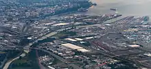
Aerial photo of Lower Puyallup River crossings in City of Tacoma (Interstate 5 near lower left corner, Commencement Bay in upper right)
This is a list of bridges and other crossings of the Puyallup River from Puget Sound upstream to its source, the Puyallup Glacier on Mount Rainier.
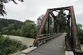
Crossings


%252C_03.jpg.webp)


See also
Notes
References
- ↑ "Puyallup Waterway Bridge", Bridgehunter.com, BH 34459
- ↑ Kate Martin (July 1, 2014), "Safety concerns prompt Tacoma to close Tideflats bridge: The City of Tacoma is closing a 103-year-old bridge on the Tideflats to all traffic in a few weeks.", Tacoma News-Tribune
- ↑ Griffes, P.L. (2004), Pacific Boating Almanac 2004: Pacific Northwest, Prostar Publications, p. 304, ISBN 978-1-57785-500-2, retrieved October 20, 2015
- ↑ U.S. Geological Survey Geographic Names Information System: East Lincoln Avenue Bridge
- ↑ U.S. Geological Survey Geographic Names Information System: Puyallup Avenue (sic) Bridge State Highway 509
- ↑ "BNSF Puyallup River bridge", Bridgehunter.com, BH 47981
- ↑ "Puyallup Avenue Bridge", Bridgehunter.com, BH 34454
- ↑ "Puyallup Avenue Bridge", HistoryLink, Seattle: History Ink
- ↑ "TRMW - Puyallup River Bridge", Bridgehunter.com, BH 47982
- ↑ John Caldbick (January 7, 2015), "Milwaukee Road's S-Turn Trestle (Tacoma)", HistoryLink, Seattle: History Ink
- ↑ U.S. Geological Survey Geographic Names Information System: Puyallup Avenue (sic) Bridge Interstate 5
- ↑ "UP - Puyallup River Bridge", Bridgehunter.com, BH 48276
- ↑ "George Milroy Bridge", Bridgehunter.com
- ↑ Puyallup River/ Meridian Street Bridge project overview, Washington State Department of Transportation
- ↑ SR 167 - Puyallup River Bridge replacement project, Washington State Department of Transportation, October 2015, retrieved October 21, 2015
- ↑ "City of Puyallup > Milwaukee Bridge Replacement". Archived from the original on March 19, 2015. Retrieved October 19, 2015.
- ↑ "Figure 2-1 Vicinity Map", Green River Watershed Management Plan (Volume 2), Tacoma Water/Tacoma Public Utilities, p. 2–6, June 2006
- ↑ Czuba et al. 2012, p. 13.
- ↑ U.S. Geological Survey Geographic Names Information System: Electron diversion dam
- ↑ Kapowsin Timberlands Vicinity Map, Hancock Forest Management
Books
- Czuba, Jonathan A.; Magirl, Christopher S.; Czuba, Christina R.; Johnson, Kenneth H.; Olsen, Theresa D.; Curran, Christopher A.; Kimball, Halley K.; Gish, Casey C. (2012), Geomorphic Analysis of the River Response to Sedimentation Downstream of Mount Rainier, Washington, U.S. Geological Survey Open-File Report, U.S. Department of the Interior, U.S. Geological Survey, Open File Report 2012-1242, retrieved October 23, 2015
Further reading
External links
Wikimedia Commons has media related to Bridges over the Puyallup River.
- Pierce County bridges at uglybridges.com
This article is issued from Wikipedia. The text is licensed under Creative Commons - Attribution - Sharealike. Additional terms may apply for the media files.