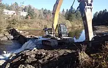
The 2017 removal of the East Burke Dam from the Passumpsic River in East Burke.
This is a list of dams in Vermont that have been removed as physical impediments to free-flowing rivers or streams.
Completed removals
| Dam[1] | Height | Year removed | Location | Watercourse | Watershed | Notes |
|---|---|---|---|---|---|---|
| Lawrence Dam (Guilford Dam) | 6 ft (1.8 m) | 2021 | Guilford 42°47′06″N 72°35′53″W / 42.7851°N 72.598°W |
Broad Brook | Connecticut River | Pond dam. |
| Norwich Reservoir Dam | 20 ft (6.1 m) | 2018 | Norwich 43°43′48″N 72°19′56″W / 43.7299°N 72.3323°W |
Charles Brown Brook | Owned by Norwich Fire District No. 1. | |
| Wyoming Paper Co. Dam Remnant | 3 ft (0.91 m) | 2022 | Guildhall 44°33′50″N 71°33′35″W / 44.5638°N 71.5597°W |
Connecticut River | Mill dam. | |
| Johnson Dam | 8 ft (2.4 m) | 2019 | Dummerston 42°55′01″N 72°33′19″W / 42.917°N 72.5553°W |
Tributary to Connecticut River | ||
| Upper Hurricane Reservoir Dam | 2010 | White River Junction 43°38′35″N 72°22′22″W / 43.6431°N 72.3727°W |
Tributary to Kilburn Brook | |||
| Lower Hurricane Reservoir Dam | 2012 | White River Junction 43°38′48″N 72°22′09″W / 43.6468°N 72.3691°W |
Tributary to Kilburn Brook | |||
| Harrington Road Dam | 2017 | West Windsor 43°27′46″N 72°28′43″W / 43.4628°N 72.4785°W |
Mill Brook | Project resulted in only partial removal of the dam.[2] | ||
| Ascutney Snowmaking Diversion Dam | 3 ft (0.91 m) | 2017 | West Windsor 43°28′00″N 72°28′15″W / 43.4668°N 72.4709°W |
Dam formerly used for snowmaking at Ascutney Mountain Resort. Owned by the Town of West Windsor.[3] | ||
| Henne Dam | 6 ft (1.8 m) | 2020 | Weathersfield 43°25′13″N 72°27′10″W / 43.4202°N 72.4529°W |
Tributary to Mill Brook | ||
| Zebedee Wetland Dam | 4 ft (1.2 m) | 2010 | Thetford 43°49′23″N 72°13′25″W / 43.8231°N 72.2236°W |
Zebedee Brook | Water supply dam owned by the Upper Valley Land Trust. | |
| Cold Brook Dam | 3 ft (0.91 m) | 2018 | Wilmington 42°53′57″N 72°51′35″W / 42.8993°N 72.8597°W |
Cold Brook | Deerfield River | [4] |
| Red Mill Dam | 1974 | Arlington 43°06′20″N 73°15′30″W / 43.1056°N 73.2584°W |
Batten Kill | Hudson River | ||
| Dufresne Dam | 12 ft (3.7 m) | 2013 | Manchester 43°10′45″N 73°01′49″W / 43.1793°N 73.0303°W |
Mill dam later used for recreation. Owned by the State of Vermont. | ||
| Henry Bridge Dam | 2013 | North Bennington 42°54′44″N 73°15′16″W / 42.9123°N 73.2544°W |
Walloomsac River | Paper mill dam. | ||
| Crooked Creek Button Farm Dam (Colchester Dam) | 11 ft (3.4 m) | 2022 | Colchester 44°32′09″N 73°10′06″W / 44.5358°N 73.1683°W |
Crooked Creek | Lake Champlain | Farm pond dam owned by the Vermont Land Trust. |
| Mill Pond Dam | 12 ft (3.7 m) | 2019 | Colchester 44°32′30″N 73°09′10″W / 44.5418°N 73.1527°W |
Indian Brook | ||
| Johnson State Dam | 30 ft (9.1 m) | 2003 | Johnson 44°38′39″N 72°40′28″W / 44.6442°N 72.6744°W |
Tributary to Lamoille River | Lamoille River | Dam built for aesthetic purposes on the campus of Johnson State College. |
| Stevensville Brook Dam | 10 ft (3.0 m) | 2008 | Underhill 44°30′24″N 72°52′01″W / 44.5066°N 72.8669°W |
Stevensville Brook | Dam built for swimming. Privately owned. | |
| Pelletier Dam | 20 ft (6.1 m) | 2022 | Castleton 43°37′19″N 73°09′44″W / 43.622°N 73.1623°W |
Breton Brook | Mettawee River | Marble mill dam owned by the Vermont Department of Fish and Wildlife. VT00349. |
| Reynolds Dam | 2022 | Dorset 43°15′39″N 73°05′18″W / 43.2607°N 73.0883°W |
Mettawee River | Dam built for recreation. | ||
| East Highgate Dam | 2017 | Highgate 44°56′N 72°59′W / 44.93°N 72.99°W |
Missisquoi River | Missisquoi River | Former mill and manufacturing dam. Mostly destroyed during the Great Vermont Flood of 1927. Remnants removed in 2017 to improve safety on the Northern Forest Canoe Trail.[5][6] | |
| Johnson Mill Dam | 17 ft (5.2 m) | 2021 | Bakersfield 44°49′54″N 72°45′20″W / 44.8316°N 72.7556°W |
Bogue Branch | Mill dam. | |
| Montague Dam | 13 ft (4.0 m) | 2022 | Post Mills 43°52′57″N 72°15′42″W / 43.8825°N 72.2617°W |
Ompompanoosuc River | Ompompanoosuc River | Mill dam. |
| Geer Dam | 6 ft (1.8 m) | 2017 | West Fairlee 43°54′48″N 72°15′44″W / 43.9134°N 72.2621°W |
Hydropower dam. | ||
| Hillside Farm Dam | 18 ft (5.5 m) | 2003 | Norwich 43°47′05″N 72°16′14″W / 43.7846°N 72.2705°W |
Tributary to Ompompanoosuc River | ||
| Pinney Hollow Brook Dam | 12 ft (3.7 m) | 2007 | Plymouth 43°33′13″N 72°42′27″W / 43.5535°N 72.7076°W |
Pinney Hollow Brook | Ottauquechee River | Dam built for swimming at Coolidge State Park. |
| East Pittsford Dam | Pittsford 43°40′39″N 72°56′54″W / 43.6774°N 72.9482°W |
East Creek | Otter Creek | |||
| Beaver Pond Dam | 12 ft (3.7 m) | 2013 | Mendon 43°40′04″N 72°51′17″W / 43.6677°N 72.8548°W |
Tributary to Mendon Brook | Dam built for recreation, owned by the Vermont Department of Fish and Wildlife. | |
| Lower Eddy Pond Dam | 20 ft (6.1 m) | 1981 | Rutland 43°35′31″N 72°57′45″W / 43.5919°N 72.9626°W |
Mussey Brook | ||
| Kendrick Pond Dam | 13 ft (4.0 m) | 2014 | Pittsford 43°43′23″N 73°01′16″W / 43.723°N 73.021°W |
Sugar Hollow Brook | Ice pond dam owned by the Town of Pittsford. | |
| Dunklee Pond Dam | 10 ft (3.0 m) | 2021 | Rutland 43°37′17″N 72°58′27″W / 43.6214°N 72.9741°W |
Tenney Brook | Mill dam. National Inventory of Dams ID VT00376. | |
| Youngs Brook Dam | 46 ft (14 m) | 1995 | West Rutland 43°34′20″N 73°03′06″W / 43.5722°N 73.0517°W |
Youngs Brook | National Inventory of Dams ID VT00165. | |
| East Burke Dam | 13 ft (4.0 m) | 2017 | East Burke 44°35′19″N 71°56′48″W / 44.5885°N 71.9466°W |
Passumpsic River | Passumpsic River | Mill dam owned by the Passumpsic Valley Land Trust. |
| Lyndon State College Lower Dam | Lyndon 44°32′12″N 72°01′26″W / 44.5368°N 72.0238°W |
Tributary to Passumpsic River | ||||
| Browns Mill Dam | 2021 | West Burke 44°38′31″N 71°58′46″W / 44.6419°N 71.9794°W |
Sutton River | |||
| Newport No. 11 Dam | 19 ft (5.8 m) | 1996 | Newport 44°56′10″N 72°11′00″W / 44.9362°N 72.1832°W |
Clyde River | St. Francois River | |
| Newport Remnant Dam | 2006 | Newport 44°56′14″N 72°10′47″W / 44.9373°N 72.1797°W |
||||
| Groton Dam (Sanville Dam) | 5 ft (1.5 m) | 1998 | Groton 44°12′36″N 72°11′52″W / 44.2101°N 72.1979°W |
Wells River | Wells River | |
| Franconia Paper Co. Dam | 6 ft (1.8 m) | 2014 | Groton 44°13′12″N 72°13′02″W / 44.2201°N 72.2173°W |
Owned by the Vermont Agency of Transportation. | ||
| Groton #9 Dam | 10 ft (3.0 m) | 2015 | Groton 44°12′30″N 72°11′29″W / 44.2082°N 72.1913°W |
Mill dam owned by Green Mountain Power. | ||
| Kidder Hill Dam | 6 ft (1.8 m) | 2019 | Grafton 43°10′07″N 72°36′23″W / 43.1687°N 72.6063°W |
Saxtons River | West River | Owned by the Connecticut River Conservancy. |
| Dalewood Dam | 2006 | Jamaica 43°06′32″N 72°51′17″W / 43.1088°N 72.8548°W |
Tributary to North Branch Ball Mountain Brook | |||
| Weston Lower Dam | 2019 | Weston 43°17′30″N 72°47′45″W / 43.2918°N 72.7958°W |
Tributary to West River | |||
| Bagatelle Dam | 7 ft (2.1 m) | 2017 | Dummerston 42°56′00″N 72°35′56″W / 42.9334°N 72.599°W |
Tributary to West River | Ice pond dam.[4] | |
| Magic Mountain Dam | 8 ft (2.4 m) | 2020 | Londonderry 43°12′29″N 72°46′36″W / 43.2081°N 72.7767°W |
Thompsonburg Brook | Dam used for snowmaking at Magic Mountain Ski Area. | |
| Montagna Dams 1 & 2 | 2021 | Windham 43°09′N 72°44′W / 43.15°N 72.73°W |
Turkey Mountain Brook | Pond dam. | ||
| Lower Eaton Dam | 15 ft (4.6 m) | 2019 | Royalton 43°49′56″N 72°30′54″W / 43.8322°N 72.515°W |
First Branch White River | White River | Saw mill and grist mill dam. |
| Upper Eaton Dam | 8 ft (2.4 m) | 2019 | South Royalton 43°49′56″N 72°30′49″W / 43.8322°N 72.5137°W |
Hydropower dam. | ||
| Camp Killooleet Dam | 14 ft (4.3 m) | 2018 | Hancock 43°55′36″N 72°50′46″W / 43.9268°N 72.8461°W |
Hancock Branch | Diversion dam to feed a trout fishing pond. | |
| Hyde Dam | 14 ft (4.3 m) | 2021 | Bethel 43°52′20″N 72°35′11″W / 43.8721°N 72.5863°W |
Second Branch White River | Saw mill and grist mill dam owned by the Vermont River Conservancy. | |
| Randolph Dam (Sargent, Osgood, and Roundy Dam) | 4 ft (1.2 m) | 2016 | Randolph 43°55′36″N 72°39′57″W / 43.9267°N 72.6659°W |
Third Branch White River | Dam built to protect bridge abutments from scour. Owned by the Town of Randolph. | |
| Camp Wihakowi Dam | 13 ft (4.0 m) | 2020 | Northfield 44°06′23″N 72°40′31″W / 44.1064°N 72.6754°W |
Bull Run | Winooski River | Summer camp recreation dam. |
| Cox Brook Dam | 10 ft (3.0 m) | 2008 | Northfield Falls 44°10′26″N 72°39′17″W / 44.1738°N 72.6546°W |
Cox Brook | Built to provide students at Norwich University with practical experience in engineering and hydraulics. | |
| Shashoua Dam | 20 ft (6.1 m) | 2018 | Warren 44°05′34″N 72°50′41″W / 44.0927°N 72.8447°W |
Tributary to Mad River | ||
| Union Brook Dam | 18 ft (5.5 m) | 2010 | Northfield 44°09′41″N 72°40′49″W / 44.1614°N 72.6803°W |
Union Brook | ||
| Marshfield-8 Dam | 11 ft (3.4 m) | 2012 | Marshfield 44°21′01″N 72°21′06″W / 44.3503°N 72.3517°W |
Winooski River | Hydropower dam. |
See also
References
- ↑ Rivers, American (13 February 2023). "American Rivers Dam Removal Database". Figshare. American Rivers. doi:10.6084/m9.figshare.5234068.v10. Retrieved 25 August 2023.
- ↑ "AUTHORIZATION TO CONDUCT STREAM ALTERATION ACTIVITIES: SA-116-2016 West Windsor Brettell Dam Removal" (PDF). Vermont Department of Environmental Conservation. 3 January 2017. Retrieved 7 September 2023.
- ↑ "Ascutney Dam To Be Removed". Valley News. 26 January 2017. Retrieved 7 September 2023.
- 1 2 Audette, Robert (12 August 2016). "Dams in Dummerston, Wilmington to be demolished". Brattleboro Reformer. Retrieved 7 September 2023.
- ↑ "Help us remove Missisquoi River dam remains". Northern Forest Canoe Trail. 19 July 2016. Retrieved 7 September 2023.
- ↑ "Workers remove East Highgate Dam on canoe trail". The County. 25 August 2017. Retrieved 7 September 2023.
External links
 Media related to Removed dams in Vermont at Wikimedia Commons
This article is issued from Wikipedia. The text is licensed under Creative Commons - Attribution - Sharealike. Additional terms may apply for the media files.