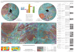
Geologic Map of Ganymede (February 11, 2014).
This is a list of named geological features, except craters, on Ganymede, a moon of Jupiter. The list is complete as of August 2022.
Catenae (crater chains)
| Name | Coordinates | Diameter (km) | Approval Date | Namesake | Refs |
|---|---|---|---|---|---|
| Enki Catena | 38°50′N 13°52′W / 38.84°N 13.86°W | 160 | 1997 | Enki, Principal water god of the Apsu. | WGPSN |
| Khnum Catena | 32°54′N 10°44′W / 32.90°N 10.73°W | 66 | 1997 | Khnum, Egyptian creation god. | WGPSN |
| Nanshe Catena | 15°24′N 352°54′W / 15.4°N 352.9°W | 103.8 | 1997 | Goddess of springs and canals, daughter of Enki. | WGPSN |
| Terah Catena | 7°06′N 277°36′W / 7.1°N 277.6°W | 283 | 2000 | Phoenician moon god who battled with Keret in Negeb. | WGPSN |
Faculae
| Name | Coordinates | Diameter (km) | Approval Date | Namesake | Refs |
|---|---|---|---|---|---|
| Abydos Facula | 33°24′N 153°24′W / 33.4°N 153.4°W | 180 | 1985 | Abydos, Egyptian town where Osiris was worshipped. | WGPSN |
| Akhmin Facula | 27°42′N 189°30′W / 27.7°N 189.5°W | 245 | 1997 | Akhmim, Egyptian town where Min was worshipped. | WGPSN |
| Bigeh Facula | 29°00′N 265°42′W / 29°N 265.7°W | 224 | 2000 | Bigeh, island where Hapi, Egyptian Nile god, resided. | WGPSN |
| Busiris Facula | 15°42′N 215°24′W / 15.7°N 215.4°W | 369 | 1985 | Busiris, town in lower Egypt where Osiris was first installed as local god. | WGPSN |
| Buto Facula | 13°12′N 203°30′W / 13.2°N 203.5°W | 245 | 1985 | Swamp where Isis hid Osiris' body. | WGPSN |
| Coptos Facula | 9°54′N 209°12′W / 9.9°N 209.2°W | 329 | 1985 | Coptos, early town from which caravans departed. | WGPSN |
| Edfu Facula | 25°42′N 147°06′W / 25.7°N 147.1°W | 184 | 1985 | Edfu, Egyptian town where Horus was worshipped. | WGPSN |
| Heliopolis Facula | 18°30′N 147°12′W / 18.5°N 147.2°W | 50 | 1997 | Heliopolis, sacred Egyptian city of the sun. | WGPSN |
| Hermopolis Facula | 22°24′N 195°18′W / 22.4°N 195.3°W | 260 | 1997 | Hermopolis, place where Unut was worshipped. | WGPSN |
| Memphis Facula | 14°06′N 131°54′W / 14.1°N 131.9°W | 361 | 1985 | Memphis, ancient capital of lower kingdom. | WGPSN |
| Siwah Facula | 7°00′N 143°06′W / 7.0°N 143.1°W | 220 | 1985 | Siwa, oasis oracle of Zeus-Ammon; visited by Alexander. | WGPSN |
| Tettu Facula | 37°36′N 161°12′W / 37.6°N 161.2°W | 189 | 1985 | Egyptian town where Hatmenit and Osiris were worshipped. | WGPSN |
| Thebes Facula | 7°06′N 202°24′W / 7.1°N 202.4°W | 360 | 1985 | Thebes, ancient capital of upper kingdom. | WGPSN |
Fossae (ditches)
| Name | Coordinates | Diameter (km) | Approval Date | Namesake | Refs |
|---|---|---|---|---|---|
| Lakhamu Fossa | 11°36′S 227°42′W / 11.6°S 227.7°W | 370 | 1985 | Dragon monster, or divine natural force produced by Apsu and Tiamat. | WGPSN |
| Lakhmu Fossae | 50°24′N 128°00′W / 50.4°N 128.0°W | 3,700 | 1985 | Lahmu, dragon monster, or divine natural force produced by Apsu and Tiamat. | WGPSN |
| Zu Fossae | 38°30′N 150°30′W / 38.5°N 150.5°W | 2,900 | 1985 | Anzû (Zu), dragon of chaos slain by Marduk. | WGPSN |
Paterae
| Name | Coordinates | Diameter (km) | Approval Date | Namesake | Refs |
|---|---|---|---|---|---|
| Hammamat Patera | 24°14′S 318°06′W / 24.23°S 318.1°W | 45 | 2015 | Wadi Hammamat in Egypt, associated with petroglyphs and ancient mining. | WGPSN |
| Hamra Patera | 77°21′S 171°22′W / 77.35°S 171.37°W | 43 | 2015 | Wadi in Jordan, associated with red sandstone cliffs and ancient copper mines. | WGPSN |
| Musa Patera | 31°21′S 188°28′W / 31.35°S 188.46°W | 69 | 2015 | Wadi Musa in Jordan, proximal to Petra archeological site. | WGPSN |
| Natrun Patera | 30°56′S 183°16′W / 30.93°S 183.26°W | 37.5 | 2015 | Wadi El Natrun in Egypt, site of ancient monasteries, proximal to site of Antoine de Saint-Exupéry’s aircraft crash that inspired the novella “The Little Prince”. | WGPSN |
| Rum Patera | 30°40′S 182°49′W / 30.66°S 182.82°W | 38 | 2015 | Wadi Rum in Jordan associated with travels of T. E. Lawrence, petroglyphs, and several Neolithic sites. | WGPSN |
| Yaroun Patera | 46°39′S 142°09′W / 46.65°S 142.15°W | 96 | 2015 | Wadi Yaroun in Lebanon, Neolithic archaeological site. | WGPSN |
Regiones
| Name | Coordinates | Diameter (km) | Approval Date | Namesake | Refs |
|---|---|---|---|---|---|
| Barnard Regio | 6°48′S 11°36′W / 6.8°S 11.6°W | 3,200 | 1979 | Edward E.; American astronomer (1857-1923). | WGPSN |
| Galileo Regio | 45°N 127°W / 45°N 127°W | 4,440 | 1979 | Galileo Galilei, Italian astronomer (1564-1642). | WGPSN |
| Marius Regio | 2°30′N 187°42′W / 2.5°N 187.7°W | 4,940 | 1979 | Simon; German astronomer (1570-1624). | WGPSN |
| Melotte Regio | 12°00′S 245°00′W / 12.0°S 245°W | 4,100 | 2013 | Philibert Jacques; British astronomer (1880-1961). | WGPSN |
| Nicholson Regio | 33°06′S 6°24′W / 33.1°S 6.4°W | 3,900 | 1979 | Seth Barnes; American astronomer (1891-1963). | WGPSN |
| Perrine Regio | 34°N 28°W / 34°N 28°W | 3,800 | 1979 | Charles D.; American astronomer (1867-1951). | WGPSN |
Sulci
| Name | Coordinates | Diameter (km) | Approval Date | Namesake | Refs |
|---|---|---|---|---|---|
| Akitu Sulcus | 38°54′N 194°18′W / 38.9°N 194.3°W | 365 | 1997 | Where Marduk's statue was carried each year. | WGPSN |
| Anshar Sulcus | 18°00′N 197°54′W / 18.0°N 197.9°W | 1,372 | 1979 | Assyro-Babylonian; celestial-world home of Lakhmu and Lakhamu. | WGPSN |
| Apsu Sulci | 39°24′S 234°42′W / 39.4°S 234.7°W | 1,950 | 1979 | Sumero-Akkadian; primordial ocean. | WGPSN |
| Aquarius Sulcus | 52°24′N 3°54′W / 52.4°N 3.9°W | 1,420 | 1979 | Greek; Zeus set Ganymede among the stars as the constellation of Aquarius, the water carrier. | WGPSN |
| Arbela Sulcus | 21°06′S 349°48′W / 21.1°S 349.8°W | 1,940 | 1985 | Assyrian town where Ishtar was worshipped. | WGPSN |
| Babylon Sulcus | 22°30′S 264°30′W / 22.5°S 264.5°W | 3,100 | July 29, 2013 | Assyro-Babylonian town in the land known as Akkad. | WGPSN |
| Borsippa Sulcus | 60°00′S 359°54′W / 60.0°S 359.9°W | 3,300 | July 29, 2013 | Akkadian town, location of the Sumerian god Nabu's principal sanctuary | WGPSN |
| Bubastis Sulci | 72°18′S 282°54′W / 72.3°S 282.9°W | 2,651 | 1988 | Town in Egypt where Bast was worshipped. | WGPSN |
| Byblus Sulcus | 37°54′N 199°54′W / 37.9°N 199.9°W | 645 | 1997 | Ancient Phoenician city where Adonis was worshipped. | WGPSN |
| Dardanus Sulcus | 46°54′S 17°30′W / 46.9°S 17.5°W | 2,988 | 1979 | Greek; where Ganymede was abducted by Zeus disguised as an eagle. | WGPSN |
| Dukug Sulcus | 83°30′N 3°48′W / 83.5°N 3.8°W | 385 | 1985 | Sumerian holy cosmic chamber of the gods. | WGPSN |
| Elam Sulci | 58°12′N 200°18′W / 58.2°N 200.3°W | 1,855 | 1985 | Ancient Babylonian seat of sun worship, in present-day Iran. | WGPSN |
| Erech Sulcus | 7°18′S 179°12′W / 7.3°S 179.2°W | 953 | 1985 | Akkadian town that was built by Marduk. | WGPSN |
| Harpagia Sulcus | 11°42′S 318°42′W / 11.7°S 318.7°W | 1,792 | 1985 | Greek; where Ganymede was abducted by an eagle. | WGPSN |
| Hursag Sulcus | 9°42′S 233°06′W / 9.7°S 233.1°W | 750 | 1985 | Sumerian mountain where winds dwell. | WGPSN |
| Kishar Sulcus | 6°24′S 216°36′W / 6.4°S 216.6°W | 1,187 | 1979 | Assyro-Babylonian; terrestrial-world home of Lakhmu and Lakhamu. | WGPSN |
| Lagash Sulcus | 10°54′S 163°12′W / 10.9°S 163.2°W | 1,575 | 1985 | Early Babylonian town. | WGPSN |
| Larsa Sulcus | 3°48′N 248°42′W / 3.8°N 248.7°W | 1,000 | 2000 | Sumerian town. | WGPSN |
| Mashu Sulcus | 29°48′N 205°42′W / 29.8°N 205.7°W | 2,960 | 1979 | Assyro-Babylonian; mountain with twin peaks where sun rose and set. | WGPSN |
| Mummu Sulcus | 39°00′S 180°00′W / 39.0°S 180.0°W | 2,680 | July 29, 2013 | Assyro-Babylonian; the tumult of the waves at the place where the waters of primordial freshwater ocean Apsu and salt sea Tiamat are mingled. | WGPSN |
| Mysia Sulci | 7°00′S 7°54′W / 7.0°S 7.9°W | 5,066 | 1979 | Greek; where Ganymede was abducted by an eagle. | WGPSN |
| Nineveh Sulcus | 23°30′N 53°06′W / 23.5°N 53.1°W | 1,700 | 1997 | City where Ishtar was worshipped. | WGPSN |
| Nippur Sulcus | 36°54′N 185°00′W / 36.9°N 185.0°W | 1,425 | 1985 | Sumerian city. | WGPSN |
| Nun Sulci | 49°30′N 316°24′W / 49.5°N 316.4°W | 1,500 | 1979 | Egyptian; chaos; primordial ocean; held germ of all things. | WGPSN |
| Philae Sulcus | 65°30′N 169°00′W / 65.5°N 169.0°W | 900 | 1997 | Temple that was the chief sanctuary of Isis. | WGPSN |
| Philus Sulcus | 44°06′N 209°30′W / 44.1°N 209.5°W | 465 | 1979 | Greek; where Ganymede and Hebe were worshipped as rain-givers. | WGPSN |
| Phrygia Sulcus | 12°24′N 23°30′W / 12.4°N 23.5°W | 3,700 | 1979 | Greek; kingdom in Asia Minor where Ganymede was born. | WGPSN |
| Shuruppak Sulcus | 19°18′S 232°12′W / 19.3°S 232.2°W | 2,800 | 2000 | Assyro-Babylonian town on the banks of the Euphrates River where the gods planned the great flood. | WGPSN |
| Sicyon Sulcus | 32°42′N 18°30′W / 32.7°N 18.5°W | 2,125 | 1979 | Greek; where Ganymede and Hebe were worshipped as rain-givers. | WGPSN |
| Sippar Sulcus | 15°24′S 189°18′W / 15.4°S 189.3°W | 1,508 | 1985 | Ancient Babylonian town. | WGPSN |
| Tiamat Sulcus | 3°24′N 208°30′W / 3.4°N 208.5°W | 1,330 | 1979 | Assyro-Babylonian; tumultuous sea from which everything was generated. | WGPSN |
| Umma Sulcus | 4°06′N 250°00′W / 4.1°N 250.0°W | 1,270 | 2000 | Sumerian town. | WGPSN |
| Ur Sulcus | 49°48′N 177°30′W / 49.8°N 177.5°W | 1,145 | 1985 | Ancient Sumerian seat of moon worship. | WGPSN |
| Uruk Sulcus | 0°48′N 160°18′W / 0.8°N 160.3°W | 2,200 | 1979 | Babylonian city ruled by Gilgamesh. | WGPSN |
| Xibalba Sulcus | 43°48′N 71°06′W / 43.8°N 71.1°W | 2,200 | 1997 | Mayan "place of fright"; destination of those who escaped violent death. | WGPSN |
See also
Wikimedia Commons has media related to Maps of Ganymede.
References
| Geology |
|  | ||||||||||||
|---|---|---|---|---|---|---|---|---|---|---|---|---|---|---|
| Exploration |
| |||||||||||||
| Other | ||||||||||||||
This article is issued from Wikipedia. The text is licensed under Creative Commons - Attribution - Sharealike. Additional terms may apply for the media files.