This is an incomplete list of ghost towns on California.

Classification

Barren site

  • Sites no longer in existence
  • Sites that have been destroyed
  • Covered with water
  • Reverted to pasture
  • May have a few difficult to find foundations/footings at most

Neglected site

  • Only rubble left
  • Roofless building ruins
  • Buildings or houses still standing, but majority are roofless

Abandoned site

  • Building or houses still standing
  • Buildings and houses all abandoned
  • No population, except caretaker
  • Site no longer in existence except for one or two buildings, for example old church, grocery store

Semi abandoned site

  • Building or houses still standing
  • Buildings and houses largely abandoned
  • few residents
  • many abandoned buildings
  • Small population

Historic community

  • Building or houses still standing
  • Still a busy community
  • Smaller than its boom years
  • Population has decreased dramatically, to one fifth or less.

List

Town Other namesCountyLatitude/Longitude Founded Abandoned Status Remarks
Agua Fria Mariposa37°29′06″N 120°01′13″W / 37.48500°N 120.02028°W / 37.48500; -120.02028 1850 1862[1] Barren[2]
Agua Mansa San Bernardino34°02′31″N 117°21′50″W / 34.04194°N 117.36389°W / 34.04194; -117.36389 After 1862[3] Barren[4] Declined slowly after the Great Flood of 1862.[3]
Alma Lexington[5]Santa Clara37°10′48″N 121°58′48″W / 37.18000°N 121.98000°W / 37.18000; -121.98000 1952 Submerged Already declined to less than 100 residents, Alma was demolished during the 1952 construction of the James J. Lenihan Dam. Currently the few remaining structures are underneath the Lexington Reservoir and can only be seen during low water levels.[6]
Amboy San Bernardino34°33′25″N 115°44′42″W / 34.55694°N 115.74500°W / 34.55694; -115.74500 Semi-abandoned
Ashford Mill Inyo35°55′08″N 116°41′05″W / 35.91889°N 116.68472°W / 35.91889; -116.68472 1914
Asphalto Kern35°18′17″N 119°36′03″W / 35.30472°N 119.60083°W / 35.30472; -119.60083 1900
Atolia San Bernardino35°18′53″N 117°36′33″W / 35.31472°N 117.60917°W / 35.31472; -117.60917 2007
Avena Inyo [7]
Bagdad San Bernardino34°34′58″N 115°52′32″W / 34.58278°N 115.87556°W / 34.58278; -115.87556 Barren[8]
Ballarat Inyo36°02′52″N 117°13′24″W / 36.04778°N 117.22333°W / 36.04778; -117.22333 The Manson Family left graffiti here.
Banta San Joaquin ValleySan Joaquin37°45′16″N 121°22′11″W / 37.75444°N 121.36972°W / 37.75444; -121.36972
Barnes Settlement Kern
Beeks Place Orange33°49′14″N 117°38′20″W / 33.82049°N 117.63878°W / 33.82049; -117.63878
Belleville San Bernardino34°18′4″N 116°53′3″W / 34.30111°N 116.88417°W / 34.30111; -116.88417
Bennettville Mono37°56′15″N 119°15′38″W / 37.93750°N 119.26056°W / 37.93750; -119.26056
Bend City Inyo36°49′09″N 118°07′50″W / 36.81917°N 118.13056°W / 36.81917; -118.13056
Benton Mono37°49′09″N 118°28′35″W / 37.81917°N 118.47639°W / 37.81917; -118.47639
Bestville Siskiyou41°18′03″N 123°08′35″W / 41.3007°N 123.1431°W / 41.3007; -123.1431
Blue Mountain Calaveras38°22′15″N 120°21′59″W / 38.37080°N 120.36642°W / 38.37080; -120.36642
Bodie Mono38°12′44″N 119°00′44″W / 38.21222°N 119.01222°W / 38.21222; -119.01222
Bondville Mariposa
Borel Mariposa
Branson City San Diego33°04′41″N 116°37′02″W / 33.07806°N 116.61722°W / 33.07806; -116.61722
Calico San Bernardino34°56′56″N 116°51′51″W / 34.94889°N 116.86417°W / 34.94889; -116.86417 1881 [9]
Camanche Calaveras38°12′48″N 120°56′07″W / 38.21333°N 120.93528°W / 38.21333; -120.93528
Camp Spirito Calaveras38°24′39″N 120°31′07″W / 38.41080°N 120.51851°W / 38.41080; -120.51851
Canebrake Kern35°43′42″N 118°08′18″W / 35.72833°N 118.13833°W / 35.72833; -118.13833
Canon City Trinity40°49′53″N 123°03′10″W / 40.83139°N 123.05278°W / 40.83139; -123.05278
Carnegie San Joaquin37°37′46″N 121°31′41″W / 37.62951°N 121.52797°W / 37.62951; -121.52797
Carson Hill Calaveras38°01′42″N 120°30′24″W / 38.02833°N 120.50667°W / 38.02833; -120.50667
Cement Solano38°17′34″N 121°59′46″W / 38.29278°N 121.99611°W / 38.29278; -121.99611
Cerro Gordo Inyo36°32.2626′N 117°47.70186′W / 36.5377100°N 117.79503100°W / 36.5377100; -117.79503100
Cerro Gordo Landing Inyo
Chambless San Bernardino34°33′41″N 115°32′41″W / 34.56139°N 115.54472°W / 34.56139; -115.54472
Chanz Kern
Cherokee Butte39°38′47″N 121°32′18″W / 39.64639°N 121.53833°W / 39.64639; -121.53833
Chinquapin Mariposa37°39′00″N 119°42′19″W / 37.65000°N 119.70528°W / 37.65000; -119.70528
China Camp Marin38°00′3″N 122°27′41″W / 38.00083°N 122.46139°W / 38.00083; -122.46139
Chinese Camp Tuolumne37°52′13″N 120°26′01″W / 37.87028°N 120.43361°W / 37.87028; -120.43361
Chloride City Inyo36°42′24″N 116°52′56″W / 36.70667°N 116.88222°W / 36.70667; -116.88222
Chrysopolis Inyo36°57′38″N 118°11′48″W / 36.96056°N 118.19667°W / 36.96056; -118.19667
Clarkson Kern
Clearing House Clearinghouse, Yosemite Mill Mariposa Semi-abandoned
Coleman City San Diego33°05′10″N 116°38′42″W / 33.08611°N 116.64500°W / 33.08611; -116.64500
Coso Inyo36°10′36″N 117°38′49″W / 36.17667°N 117.64694°W / 36.17667; -117.64694
Cox & Clark Trading Post and Steamboat Landing Kings35°58′08″N 119°56′21″W / 35.96898°N 119.93929°W / 35.96898; -119.93929
Coyote Santa Clara37°13′00″N 121°44′26″W / 37.21667°N 121.74056°W / 37.21667; -121.74056
Craft Kern
Cuttens Kern
Cuyamaca City San Diego32°59′05″N 116°34′15″W / 32.98472°N 116.57083°W / 32.98472; -116.57083
Darwin Inyo36°16′05″N 117°35′30″W / 36.26806°N 117.59167°W / 36.26806; -117.59167
Deadwood Placer39°04′50″N 120°41′22″W / 39.08056°N 120.68944°W / 39.08056; -120.68944
Deadwood Trinity40°43′10″N 122°44′01″W / 40.71944°N 122.73361°W / 40.71944; -122.73361
Dedrick Trinity40°51′46″N 123°02′12″W / 40.86278°N 123.03667°W / 40.86278; -123.03667
Denny Trinity40°56′38″N 123°23′12″W / 40.94389°N 123.38667°W / 40.94389; -123.38667
Desert Spring Kern35°16′20″N 118°37′34″W / 35.27222°N 118.62611°W / 35.27222; -118.62611
Dogtown Mono38°10′13″N 119°11′51″W / 38.17028°N 119.19750°W / 38.17028; -119.19750
Domino Kern
Doreleska Trinity
Drawbridge Alameda37°27′54″N 121°58′28″W / 37.46500°N 121.97444°W / 37.46500; -121.97444
Drytown Amador38°26′28″N 120°51′16″W / 38.44111°N 120.85444°W / 38.44111; -120.85444
Dunmovin Inyo36°05′19″N 117°57′40″W / 36.08861°N 117.96111°W / 36.08861; -117.96111
Eagle Mountain Riverside33°51′27″N 115°29′14″W / 33.85750°N 115.48722°W / 33.85750; -115.48722
Eastwood San Diego33°05′15″N 116°36′40″W / 33.08750°N 116.61111°W / 33.08750; -116.61111
Echo Inyo Barren
El Dorado Bar Calaveras
Eldoradoville Los Angeles34°13′47″N 117°46′11″W / 34.2297°N 117.7698°W / 34.2297; -117.7698 1862
Elliott San Joaquin38°14′05″N 121°10′51″W / 38.23472°N 121.18083°W / 38.23472; -121.18083 1846[10]
Elna Inyo37°05′38″N 118°13′28″W / 37.09389°N 118.22444°W / 37.09389; -118.22444
Empire City Stanislaus37°38.239′N 120°54.167′W / 37.637317°N 120.902783°W / 37.637317; -120.902783
Emory Mariposa
Essex San Bernardino34°44′01″N 115°14′42″W / 34.73361°N 115.24500°W / 34.73361; -115.24500
Falk Humboldt
Fountain Springs Tulare35°53′28″N 118°54′56″W / 35.891111°N 118.915556°W / 35.891111; -118.915556
Freeman Junction Kern35°36′06″N 117°54′11″W / 35.60166°N 117.90295°W / 35.60166; -117.90295
Fremont Valley Calaveras
French Flat Tuolumne37°58′20″N 120°28′17″W / 37.97222°N 120.47139°W / 37.97222; -120.47139
Furnace Inyo36°11′29″N 116°39′54″W / 36.19133°N 116.66495°W / 36.19133; -116.66495
Furnace Creek Inn Inyo36°27′02″N 116°51′08″W / 36.45056°N 116.85222°W / 36.45056; -116.85222
Garlock Kern35°24′09″N 117°47′24″W / 35.40250°N 117.79000°W / 35.40250; -117.79000
Gas Point Shasta40°24′56″N 122°32′04″W / 40.41556°N 122.53444°W / 40.41556; -122.53444
Gibsonville Sierra39°44′25″N 120°54′32″W / 39.74028°N 120.90889°W / 39.74028; -120.90889
Girard Kern
Glenburn Kern
Goffs San Bernardino34°55′09″N 115°03′46″W / 34.91917°N 115.06278°W / 34.91917; -115.06278
Gold Town Kern35°00′06″N 118°10′08″W / 35.00167°N 118.16889°W / 35.00167; -118.16889
Goler Heights Kern35°25′37″N 117°44′45″W / 35.42694°N 117.74583°W / 35.42694; -117.74583
Greasertown Calaveras38°11′28″N 120°45′15″W / 38.19113°N 120.75407°W / 38.19113; -120.75407
Greenwater Inyo36°10′46″N 116°36′59″W / 36.17944°N 116.61639°W / 36.17944; -116.61639
Greenwich Kern
Gerstley Inyo36°00′43″N 116°16′28″W / 36.01190°N 116.27456°W / 36.01190; -116.27456
Grub Gulch Madera37°19′29″N 119°46′15″W / 37.32472°N 119.77083°W / 37.32472; -119.77083
Gullion's Bar Siskiyou41°17′48″N 123°21′36″W / 41.29667°N 123.36000°W / 41.29667; -123.36000
Haiwee Inyo36°08′48″N 117°58′33″W / 36.14667°N 117.97583°W / 36.14667; -117.97583
Hamilton Butte39°27′09″N 121°38′28″W / 39.45254°N 121.64108°W / 39.45254; -121.64108
Hart San Bernardino35°17′20″N 115°06′12″W / 35.28889°N 115.10333°W / 35.28889; -115.10333
Hatfields Camp Kern35°28′26″N 117°52′06″W / 35.47389°N 117.86833°W / 35.47389; -117.86833
Helena Trinity40°46′25″N 123°07′42″W / 40.77361°N 123.12833°W / 40.77361; -123.12833
Hoboken Sacramento38°33′28″N 121°25′04″W / 38.55778°N 121.41778°W / 38.55778; -121.41778
Hodson Calaveras37°59′48″N 120°41′08″W / 37.99667°N 120.68556°W / 37.99667; -120.68556
Hokokwito Mariposa37°45′30″N 119°35′43″W / 37.75833°N 119.59528°W / 37.75833; -119.59528
Holy City Santa Clara37°09′25″N 121°58′44″W / 37.1568904°N 121.9788476°W / 37.1568904; -121.9788476
Horseshoe Bend Mariposa37°40′41″N 120°13′52″W / 37.67794°N 120.23101°W / 37.67794; -120.23101
Hollands Los Angeles [11]
Igo Shasta40°30′20″N 122°32′30″W / 40.505556°N 122.541667°W / 40.505556; -122.541667
Independence Flat Calaveras
Indian Gulch Mariposa37°26′22″N 120°11′49″W / 37.43944°N 120.19694°W / 37.43944; -120.19694
Indian Springs Kern
Iowa Hill Placer39°06′31″N 120°51′34″W / 39.10861°N 120.85944°W / 39.10861; -120.85944
Isabella Kern35°39′20″N 118°27′40″W / 35.65556°N 118.46111°W / 35.65556; -118.46111
Ivanpah San Bernardino35°32′42″N 115°32′07″W / 35.54500°N 115.53528°W / 35.54500; -115.53528
Jaeger City Imperial32°43′52″N 114°37′47″W / 32.73111°N 114.62972°W / 32.73111; -114.62972
Joe Walker Town Kern35°25′20″N 118°29′35″W / 35.42222°N 118.49306°W / 35.42222; -118.49306
Joyfull Kern
Kasson Inyo
Kern River Slough Kern35°15′35″N 118°58′03″W / 35.25972°N 118.96750°W / 35.25972; -118.96750
Kernvale Kern
Kernville Kern35°42′51″N 118°26′12″W / 35.71417°N 118.43667°W / 35.71417; -118.43667
Kearsarge Inyo36°48′36″N 118°19′30″W / 36.81000°N 118.32500°W / 36.81000; -118.32500
Keeler Inyo36°29′14″N 117°52′26″W / 36.48722°N 117.87389°W / 36.48722; -117.87389
Kelso San Bernardino35°00′45″N 115°39′13″W / 35.01250°N 115.65361°W / 35.01250; -115.65361
Kingston Kings36°25′25″N 119°41′38″W / 36.42361°N 119.69389°W / 36.42361; -119.69389
Kumaini Mariposa
La Panza San Luis Obispo35°21′40″N 120°12′56″W / 35.36111°N 120.21556°W / 35.36111; -120.21556
Langdon Kern
Lavers' Crossing Kern35°44′12″N 118°43′16″W / 35.73667°N 118.72111°W / 35.73667; -118.72111
Leadfield Inyo36°50′48″N 117°03′33″W / 36.84667°N 117.05917°W / 36.84667; -117.05917
Lee Inyo
Lee Camp Kern
Leliter Kern35°42′38″N 117°49′49″W / 35.71056°N 117.83028°W / 35.71056; -117.83028
Leon Riverside33°39′09″N 117°08′08″W / 33.65250°N 117.13556°W / 33.65250; -117.13556
Lexington Santa Clara37°11′47″N 121°59′18″W / 37.19639°N 121.98833°W / 37.19639; -121.98833
Liberty San Joaquin
Linda Rosa Riverside
Lila C Inyo36°14′36″N 116°29′56″W / 36.24333°N 116.49889°W / 36.24333; -116.49889
Lillis Fresno36°26′18″N 119°43′03″W / 36.43833°N 119.71750°W / 36.43833; -119.71750
Llano del Rio Los Angeles34°30′23″N 117°49′38″W / 34.50639°N 117.82722°W / 34.50639; -117.82722
Lone Pine Station Inyo
Lookout City Inyo36°14′45″N 117°26′05″W / 36.24583°N 117.43472°W / 36.24583; -117.43472
Lower Calaveritas Calaveras
Ludlow San Bernardino34°43′16″N 116°09′36″W / 34.72111°N 116.16000°W / 34.72111; -116.16000
Lyons Station Los Angeles34°21′46″N 118°30′27″W / 34.36270°N 118.50740°W / 34.36270; -118.50740
Macheto Mariposa
Mammoth City Mono
Manchester Monterey
Manzanar Inyo36°44′24″N 118°04′50″W / 36.74000°N 118.08056°W / 36.74000; -118.08056
Martensdale Kern
Martinez Tuolumne County38°01′24″N 120°22′47″W / 38.02333°N 120.37972°W / 38.02333; -120.37972
Masonic Mono38°21′45″N 119°06′45″W / 38.36250°N 119.11250°W / 38.36250; -119.11250
Melones Calaveras38°00′45″N 120°29′55″W / 38.01250°N 120.49861°W / 38.01250; -120.49861
Mentryville Los Angeles34°22′44″N 118°36′40″W / 34.379°N 118.611°W / 34.379; -118.611
Merced Falls Merced37°31′23″N 120°19′57″W / 37.52306°N 120.33250°W / 37.52306; -120.33250
Mercuryville Sonoma38°46′34″N 122°50′22″W / 38.77611°N 122.83944°W / 38.77611; -122.83944
Midland Riverside33°51′40″N 114°48′08″W / 33.86111°N 114.80222°W / 33.86111; -114.80222
Midway Kern
Mill Valley Calaveras
Minear Mariposa
Minersville Trinity40°51′05″N 122°46′59″W / 40.85139°N 122.78306°W / 40.85139; -122.78306
Mount Ophir Mariposa37°30′53″N 120°03′53″W / 37.51472°N 120.06472°W / 37.51472; -120.06472
Miramonte Kern
Mono Mills Mono37°53′15″N 118°57′34″W / 37.88750°N 118.95944°W / 37.88750; -118.95944
Monterio Kern
Moore's Flat Nevada
Mormon Island Sacramento38°42′13″N 121°07′03″W / 38.7035°N 121.1174°W / 38.7035; -121.1174 1848 1856 Submerged
Mountain House Kern35°41′31″N 118°55′03″W / 35.69186°N 118.91759°W / 35.69186; -118.91759
Muroc Kern34°55′23″N 117°52′20″W / 34.92306°N 117.87222°W / 34.92306; -117.87222
Narka Inyo35°53′52″N 117°54′04″W / 35.89778°N 117.90111°W / 35.89778; -117.90111
Negro Flat Siskiyou41°14′31″N 123°16′51″W / 41.24194°N 123.28084°W / 41.24194; -123.28084
Neuralia Inyo
New Almaden Santa Clara37°10′48″N 121°50′08″W / 37.18000°N 121.83556°W / 37.18000; -121.83556
New Idria San Benito36°25′1″N 120°40′28″W / 36.41694°N 120.67444°W / 36.41694; -120.67444
Newtown Mariposa37°42′12″N 120°11′31″W / 37.70333°N 120.19194°W / 37.70333; -120.19194
Noonday Camp Inyo35°48′39″N 116°06′15″W / 35.81083°N 116.10417°W / 35.81083; -116.10417
Norristown Sacramento38°33′28″N 121°25′04″W / 38.55778°N 121.41778°W / 38.55778; -121.41778
North Muroc Kern35°00′18″N 117°49′08″W / 35.00500°N 117.81889°W / 35.00500; -117.81889
North Shore Riverside33°30′46″N 115°55′38″W / 33.51278°N 115.92722°W / 33.51278; -115.92722
Nortonville Contra Costa37°57′28″N 121°52′50″W / 37.95778°N 121.88056°W / 37.95778; -121.88056
Notomidula Mariposa
Olig Kern35°19′30″N 119°39′23″W / 35.32500°N 119.65639°W / 35.32500; -119.65639
Oregon Bar Calaveras
Owensville Inyo37°24′03″N 118°20′44″W / 37.40083°N 118.34556°W / 37.40083; -118.34556
Packwood Station Tulare
Panamint City Inyo36°07′06″N 117°05′43″W / 36.11833°N 117.09528°W / 36.11833; -117.09528
Pasinogna San Bernardino33°59′24″N 117°43′03″W / 33.99000°N 117.71750°W / 33.99000; -117.71750
Patchen Santa Clara
Petersburg Kern35°36′09″N 118°36′13″W / 35.60250°N 118.60361°W / 35.60250; -118.60361
Petroleopolis Los Angeles
Picacho Imperial33°01′23″N 114°36′40″W / 33.02306°N 114.61111°W / 33.02306; -114.61111
Pinacate Riverside33°45′36″N 117°14′00″W / 33.76000°N 117.23333°W / 33.76000; -117.23333
Piute Kern
Politana San Bernardino
Port Chicago Contra Costa38°02′46″N 122°01′15″W / 38.04611°N 122.02083°W / 38.04611; -122.02083
Port Wine Sierra
Prado San Bernardino
Prairie City Sacramento
Providence San Bernardino34°58′49″N 115°30′19″W / 34.98028°N 115.50528°W / 34.98028; -115.50528
Purissima San Mateo37°24′11″N 122°25′01″W / 37.40306°N 122.41694°W / 37.40306; -122.41694
Pylema Kern
Quartzburg Kern
Quartzburg Mariposa37°32′22″N 120°12′16″W / 37.53944°N 120.20444°W / 37.53944; -120.20444
Rincon San Bernardino
Reefer City Kern35°00′21″N 118°11′06″W / 35.00583°N 118.18500°W / 35.00583; -118.18500
Reilly Inyo36°00′25″N 117°22′08″W / 36.00694°N 117.36889°W / 36.00694; -117.36889
Rice San Bernardino34°05′01″N 114°50′59″W / 34.08361°N 114.84972°W / 34.08361; -114.84972
Ridleys Ferry Mariposa
Rincon San Bernardino
Rio Bravo Kern35°17′49″N 119°03′24″W / 35.29684°N 119.05678°W / 35.29684; -119.05678
Riverview Kern
Roachville Inyo
Rock Springs Kern
Sage Kern
San Carlos Inyo36°48′14″N 118°07′34″W / 36.80389°N 118.12611°W / 36.80389; -118.12611 (San Carlos, Inyo County, California)
San Joaquin City San Joaquin37°40′12″N 121°15′58″W / 37.67000°N 121.26611°W / 37.67000; -121.26611
San Miguel de los Noches Kern
Sakaya Mariposa
Sandy Bar Calaveras
Sawmill Flat Tuolumne38°01′14″N 120°22′51″W / 38.02056°N 120.38083°W / 38.02056; -120.38083
Scheelite Inyo
Schwaub Inyo36°30′20″N 116°43′25″W / 36.50556°N 116.72361°W / 36.50556; -116.72361
Scovern Hot Springs Kern35°37′17″N 118°28′27″W / 35.62139°N 118.47417°W / 35.62139; -118.47417
Second Garrotte Tuolumne37°49′30″N 120°11′51″W / 37.82500°N 120.19750°W / 37.82500; -120.19750
Seneca Plumas40°06′38″N 121°05′05″W / 40.11056°N 121.08472°W / 40.11056; -121.08472
Shamrock Kern
Shasta Shasta40°35′32″N 122°28′40″W / 40.59222°N 122.47778°W / 40.59222; -122.47778
Siberia San Bernardino34°37′36″N 115°59′09″W / 34.62667°N 115.98583°W / 34.62667; -115.98583
Silver Lake San Bernardino35°22′16″N 116°6′54″W / 35.37111°N 116.11500°W / 35.37111; -116.11500
Skidoo Inyo36°26′08″N 117°08′51″W / 36.43556°N 117.14750°W / 36.43556; -117.14750
Sloss Mariposa
Smyrna Kern
Sodan Inyo35°55′16″N 117°54′10″W / 35.92111°N 117.90278°W / 35.92111; -117.90278
Sorrell's Kern
Spanish Bar Calaveras
St. Louis Sierra
Stickneys Ferry Tulare
Stonewall San Diego
Stony Bar Calaveras
Strader Kern
Strand Kern
Stratton San Diego
Sullivan Kern
Sunland Inyo37°19′57″N 118°24′16″W / 37.33250°N 118.40444°W / 37.33250; -118.40444
Sunset Kern
Swansea Inyo36°31′29″N 117°54′14″W / 36.52472°N 117.90389°W / 36.52472; -117.90389
Taylors Bar Calaveras
Teagle Kern
Tehichipa Kern
Tejon Kern
Telegraph City Grasshopper CityCalaveras37°56′04″N 120°44′24″W / 37.934444°N 120.74°W / 37.934444; -120.74 1860 Neglected
Temescal Riverside
Terese Siding Kern
Terra Cotta Riverside33°42′11″N 117°22′29″W / 33.70306°N 117.37472°W / 33.70306; -117.37472
Timbuctoo Yuba39°13′01″N 121°19′07″W / 39.21694°N 121.31861°W / 39.21694; -121.31861
Toolwass Kern
Tumco Imperial
Unadilla Kern
Vaca Adobe Kings36°03′08″N 119°57′52″W / 36.05222°N 119.96435°W / 36.05222; -119.96435
Vallecito San Diego32°58′34″N 116°21′01″W / 32.97611°N 116.35028°W / 32.97611; -116.35028
Valley Wells San Bernardino35°49′42″N 117°19′54″W / 35.82833°N 117.33167°W / 35.82833; -117.33167
Vanderbilt San Bernardino35°19′38″N 115°14′59″W / 35.32722°N 115.24972°W / 35.32722; -115.24972
Vaughn Kern
Water Station Kern
Wenger Mariposa
Westville Placer39°10′30″N 120°38′53″W / 39.17500°N 120.64806°W / 39.17500; -120.64806
White Mountain City Inyo
Willard Riverside
Wingo Sonoma38°12′33″N 122°25′36″W / 38.20917°N 122.42667°W / 38.20917; -122.42667
Winter Garden Kern
Wiskala Mariposa
Woolsey Flat Nevada39°24′41″N 120°52′05″W / 39.41139°N 120.86806°W / 39.41139; -120.86806
Wrights Santa Clara37°08′21″N 121°56′49″W / 37.13917°N 121.94694°W / 37.13917; -121.94694
Yaqui Camp Calaveras
You Bet Nevada39°12′33″N 120°54′00″W / 39.20917°N 120.90000°W / 39.20917; -120.90000 A gold mining town
Zurich Alvord, Station[12]Inyo37°10′58″N 118°15′36″W / 37.18278°N 118.26000°W / 37.18278; -118.26000

Fresno

References

  1. Durham, David L. (1998). California's Geographic Names: A Gazetteer of Historic and Modern Names of the State. Clovis, Calif.: Word Dancer Press. p. 739. ISBN 1-884995-14-4.
  2. "Agua Fria". Office of Historic Preservation, California State Parks. Retrieved October 9, 2012.
  3. 1 2 "NO. 121 AGUA MANSA". ohp.parks.ca.gov. Office of Historical Preservation. Archived from the original on November 17, 2010. Retrieved December 11, 2010.
  4. "Agua Mansa". ghosttowns.com. Retrieved December 8, 2010.
  5. Gudde, Erwin; William Bright (2004). California Place Names (Fourth ed.). University of California Press. p. 9. ISBN 0-520-24217-3.
  6. Article by Jon M. Corry, http://ghosttowns.com/states/ca/lexingtonandalma.html
  7. "THE ORIGIN OF CERTAIN PLACE NAMES IN THE UNITED STATES" (PDF). pubs.usgs.gov. 1905. p. 33.
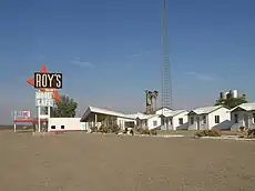
  8. Randall, Guy. "Amboy Area". www.theroadwanderer.net. Retrieved May 15, 2018.
  9. "The Most Haunted Ghost Towns". United States Ghost Towns. November 21, 2022. Retrieved May 23, 2023.
  10. "Older towns dot valley when Lodi established". Lodi News-Sentinel. September 9, 1969. pp. 8C. Retrieved October 28, 2015.
  11. Frickstad, Walter N., A Century of California Post Offices 1848-1954, Philatelic Research Society, Oakland, CA. 1955, pp. 70-84.
  12. Durham, David L. (1998). California's Geographic Names: A Gazetteer of Historic and Modern Names of the State. Clovis, Calif.: Word Dancer Press. p. 1216. ISBN 1-884995-14-4.
This article is issued from Wikipedia. The text is licensed under Creative Commons - Attribution - Sharealike. Additional terms may apply for the media files.