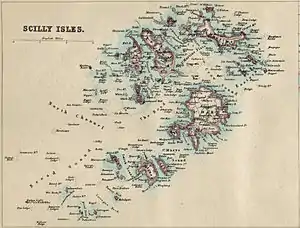
This is a list of the islands in the Isles of Scilly.[1]
Inhabited islands
There are five inhabited islands of the Isles of Scilly, Cornwall, United Kingdom (six if you count the tidal island of Gugh which is separated from St. Agnes at high tide).
| Name | Image | Coordinates | Population | Area (hectares) | Elevation (metres) |
|---|---|---|---|---|---|
| Bryher |  | 🌍 SV876361 | 83 | 122 | 42 |
| Gugh |  | 🌍[2] | 3 | 50 | 34 |
| St Agnes |  | 🌍 SV881430 | 73 | 366 | |
| St Martin's |  | 🌍 925 159 SV 925 159 | 142 | 237 | 47 |
| St Mary's |  | 🌍 SV915115 | 1723[3] (2011) | 629 | 51 |
| Tresco |  | 🌍 SV893421 | 175 (2011) | 297 | 44 |
Islands around Bryher
The following islands lie in the civil parish of Bryher, and include the group of Norrard Rocks which were designated as a Site of Special Scientific Interest in 1971. The only inhabited island in this area is Bryher itself.
| Name | Image | Coordinates | Area (hectares) |
|---|---|---|---|
| Castle Bryher |  | 🌍 SV863140 | 0.39 |
| Gweal |  | 🌍[4] SV866152 | 5.82 |
| Illiswilgig |  | 🌍 SV858139 | 0.9 |
| Maiden Bower |  | 🌍[5] SV850145 | 0.66 |
| Mincarlo |  | 🌍[6] SV853129 | 1.82 |
| Scilly Rock |  | 🌍 SV859156 | 1.98 |
| Seal Rock |  | 🌍[7] SV854141 | 0.2 |
| Zantman's Rock | 🌍 | 0.02 |
Islands around St. Agnes

The following islands lie in the civil parish of St. Agnes, and include the group of Western Rocks. The only inhabited islands in this area are St Agnes and Gugh.
| Name | Image | Coordinates | Area (hectares) |
|---|---|---|---|
| Annet |  | 🌍 | 21 |
| Biggal of Gorregan |  | 🌍[8] | |
| Burnt Island |  | 🌍[9] | |
| Daisy | 🌍[10] SV839053 | 0.57 | |
| Gilstone |  | 🌍[9] SV832053 | |
| Gorregan | 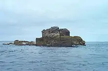 | 🌍[11] | 1.57 |
| Great Crebawethan |  | 🌍[12] SV830071 | 0.51 |
| Hellweathers |  | 🌍[13] | |
| Jacky's Rock | 🌍 | ||
| Little Crebawethan | 🌍[14] SV827069 | 0.14 | |
| Melledgan | 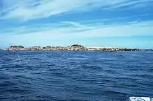 | 🌍[15] | 0.96 |
| Retarrier Ledges | 🌍[16] SV820059 | ||
| Rosevean |  | 🌍[17] SV839056 | 0.63 |
| Rosevear | 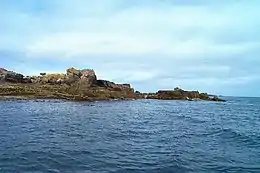 | 🌍 | 4 |
| The Brow | 🌍[18] |
Islands around St. Martin's

The following islands lie in the civil parish of St. Martin's, and include the group of Eastern Isles. The only inhabited island in this area is St Martin's itself.
| Name | Image | Coordinates | Area (hectares) |
|---|---|---|---|
| Eastern Isles |  | 🌍, 🌍 SV939149 | |
| Great Arthur |  | 🌍[19] | |
| Great Ganilly |  | 🌍[20] | 13 |
| Great Ganinick |  | 🌍[21] | |
| Great Innisvouls |  | 🌍 | |
| Guther's Island | 🌍[22] | ||
| Hanjague |  | 🌍[23] SV957150 | |
| Little Ganilly |  | 🌍[24] | |
| Little Ganinick | 🌍[25] | ||
| Little Innisvouls |  | 🌍 SV955142 | |
| Menawethan |  | 🌍 SV954137 | |
| Moths Ledge |  | 🌍 9205 1516 SV 9205 1516 | |
| Nornour |  | 🌍 SV944148 | |
| Ragged Island |  | 🌍 SV946138 | |
| White Island |  | 🌍[26] | 15 |
Islands around St. Mary's

The civil parish of St. Mary's contains the island of St Mary's itself which includes a few tidal islands which are connected at low tide.
| Name | Image | Coordinates | Area (hectares) |
|---|---|---|---|
| Newford Island |  | 🌍 | |
| Taylor's Island | .jpg.webp) | 🌍[27] | |
| Toll's Island |  | 🌍[28] |
Islands around Tresco

The following islands lie in the civil parish of Tresco. The only inhabited island in this area is Tresco itself.
| Name | Image | Coordinates | Area (hectares) |
|---|---|---|---|
| Broad Ledge |  | 🌍[29] | |
| Green Island | 🌍 | ||
| Hedge Rock | .jpg.webp) | 🌍 | |
| Mare Ledges | .jpg.webp) | 🌍 | |
| Northwethel |  | 🌍[30] SV895163 | 4.63 |
| Old Man |  | 🌍 | |
| Pednbrose |  | 🌍[31] | |
| Round Island | 🌍[32] | 1.2 | |
| Samson |  | 🌍[33] | 38 |
| St Helen's |  | 🌍 | 20 |
| Stony Island |  | 🌍[34] | |
| Teän |  | 🌍[35] | 16 |
| Tobaccoman's Ledge | 🌍[36] |
References
- ↑ "OS Maps: online mapping and walking, running and cycling routes". osmaps.ordnancesurvey.co.uk. Retrieved 12 September 2020.
- ↑ http://data.ordnancesurvey.co.uk/id/4000000074609413
- ↑ http://www.neighbourhood.statistics.gov.uk/dissemination/LeadTableView.do?a=7&b=11128887&c=Mary&d=16&e=61&g=6410894&i=1001x1003x1032x1004&o=362&m=0&r=1&s=1452792596266&enc=1&dsFamilyId=2491
- ↑ http://data.ordnancesurvey.co.uk/id/4000000074609830
- ↑ http://data.ordnancesurvey.co.uk/id/4000000074610871
- ↑ http://data.ordnancesurvey.co.uk/id/4000000074610062
- ↑ https://getoutside.ordnancesurvey.co.uk/local/seal-rock-isles-of-scilly-tr230pr
- ↑ https://getoutside.ordnancesurvey.co.uk/local/biggal-of-gorregan-isles-of-scilly
- 1 2 GeoNames, 2005, Wikidata Q830106
- ↑ https://getoutside.ordnancesurvey.co.uk/local/daisy-isles-of-scilly
- ↑ http://data.ordnancesurvey.co.uk/id/4000000074610057
- ↑ http://data.ordnancesurvey.co.uk/id/4000000074610242
- ↑ http://data.ordnancesurvey.co.uk/id/4000000074610239
- ↑ http://data.ordnancesurvey.co.uk/id/4000000074610243
- ↑ http://data.ordnancesurvey.co.uk/id/4000000074609826
- ↑ https://getoutside.ordnancesurvey.co.uk/local/retarrier-ledges-isles-of-scilly
- ↑ https://getoutside.ordnancesurvey.co.uk/local/rosevean-isles-of-scilly
- ↑ https://getoutside.ordnancesurvey.co.uk/local/the-brow-isles-of-scilly
- ↑ http://data.ordnancesurvey.co.uk/id/4000000074611672
- ↑ http://data.ordnancesurvey.co.uk/id/4000000074611073
- ↑ http://data.ordnancesurvey.co.uk/id/4000000074612875
- ↑ http://data.ordnancesurvey.co.uk/id/4000000074612323
- ↑ http://data.ordnancesurvey.co.uk/id/4000000074612076
- ↑ http://data.ordnancesurvey.co.uk/id/4000000074611074
- ↑ http://data.ordnancesurvey.co.uk/id/4000000074611494
- ↑ http://data.ordnancesurvey.co.uk/id/4000000074586630
- ↑ https://getoutside.ordnancesurvey.co.uk/local/taylors-island-isles-of-scilly
- ↑ http://data.ordnancesurvey.co.uk/id/4000000074609415
- ↑ Ordnance Survey, OL 2646211A, Wikidata Q548721
- ↑ http://data.ordnancesurvey.co.uk/id/4000000074609017
- ↑ https://getoutside.ordnancesurvey.co.uk/local/pednbrose-isles-of-scilly
- ↑ http://data.ordnancesurvey.co.uk/id/4000000074609421
- ↑ http://data.ordnancesurvey.co.uk/id/4000000074613565
- ↑ https://getoutside.ordnancesurvey.co.uk/local/stony-island-isles-of-scilly
- ↑ http://data.ordnancesurvey.co.uk/id/4000000074614827
- ↑ https://getoutside.ordnancesurvey.co.uk/local/tobaccomans-ledge-isles-of-scilly
| Inhabited islands | 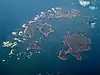 | |
|---|---|---|
| Uninhabited islands | ||
| Settlements |
| |
| Symbols | ||
| Topics |
| |