
_p06.68_-_Map_of_the_Yorkshire_Rivers.jpg.webp)
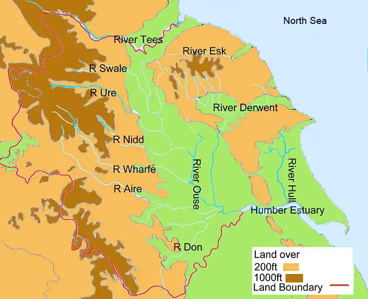
This is a list of named rivers that flow either wholly or partially within the boundaries of the four ceremonial counties that form Yorkshire. There are twenty five rivers of at least 20 kilometres (12 mi) in total. The majority of these waterways lie wholly within the county boundaries, except for; the Ribble, which flows into the Irish Sea at Lytham; the Rother, whose source is located in Derbyshire Peak District; the Greta, which flows into Lancashire to join the River Lune; and the Tees, which flows partly within County Durham and forms some of the boundary with North Yorkshire.
The direction of stream flow in Yorkshire is influenced by the three major drainage divides. The Pennines in the west and south, the North York Moors in the north-east and the Yorkshire Wolds, the coastal range of hills on the east. This represents a large drainage area that mostly flows into the Vale of York and into the North Sea via the Humber estuary. Though an estuary, the Humber is often referred to as a river.
The Humber river system is tidal as far inland as Naburn Lock on the River Ouse,[1] Knottingley on the River Aire[2][3] and Askern on the River Don.[4] The Humber has the second largest tidal range in the UK at 7.2 metres (24 ft). The largest is the Bristol Channel at nearly double that range.[5]
Source data for the table below came from the National Environment Research Council Centre for Ecology and Hydrology, Ordnance Survey, Environment Agency and Google Earth. In the table, total lengths are given in miles (mi) and kilometres (km), and elevations are in feet (ft) and metres (m). River lengths are taken from actual source when wholly within the Yorkshire County boundary, else measured from where the river enters or leaves the county.
Images
 The River Esk at Whitby
 The River Aire and the Leeds-Liverpool canal in Leeds
 River Sheaf joins River Don at Sheffield
 Tidal Barrier on the River Hull at Kingston upon Hull
.jpg.webp) Infinity Bridge on River Tees in the Borough of Stockton-on-Tees
Infinity Bridge on River Tees in the Borough of Stockton-on-Tees The road bridge at Stamford Bridge over the River Derwent
 River Wharfe at Tadcaster
 Richmond Castle and the River Swale
 River Ure at Boroughbridge
 River Nidd and railway viaduct at Knaresborough

List
The use of the term source in this list is taken to mean the point at which the name of the river is first used on Ordnance Survey maps.
| Key |
|---|
| † River length within county only |
Map
Sources
- Ordnance Survey Open Viewer https://www.ordnancesurvey.co.uk/business-government/tools-support/open-data-support
- Google Earth
- National Environment Research Council - Centre for Ecology and Hydrology
- Environment Agency
- Map of main rivers
References
- ↑ "Tidal Ouse". Environment Agency. Retrieved 18 February 2011.
- ↑ "Tidal Aire". Environment Agency. Retrieved 18 February 2011.
- ↑ "River Aire CFMP" (PDF), Aire Catchment Flood Management Plan, Environment Agency, p. 4, retrieved 18 February 2011
- ↑ "Tidal Don". Environment Agency. Retrieved 18 February 2011.
- ↑ "Tidal reach". Environment Agency. Retrieved 18 February 2011.
- ↑ "Aire Statistics". National River Flow Archives. Centre for Ecology & Hydrology. Retrieved 18 February 2011.
- ↑ "Calder Statistics". National River Flow Archives. Centre for Ecology & Hydrology. Retrieved 18 February 2011.
- ↑ "Colne Statistics". National River Flow Archives. Centre for Ecology & Hydrology. Retrieved 18 February 2011.
- 1 2 3 "River Factfiles" (PDF), The Dearne, Don and Rother Catchment, Environment Agency, p. 1, retrieved 19 February 2011
- ↑ "Dearne Statistics". National River Flow Archives. Centre for Ecology & Hydrology. Retrieved 18 February 2011.
- ↑ "Derwent Statistics". National River Flow Archives. Centre for Ecology & Hydrology. Retrieved 18 February 2011.
- ↑ "Dibb Statistics". National River Flow Archives. Centre for Ecology & Hydrology. Retrieved 18 February 2011.
- ↑ "Don Statistics". National River Flow Archives. Centre for Ecology & Hydrology. Retrieved 18 February 2011.
- ↑ "Dove, N.Yorks Statistics". National River Flow Archives. Centre for Ecology & Hydrology. Retrieved 18 February 2011.
- ↑ "Esk Statistics". National River Flow Archives. Centre for Ecology & Hydrology. Retrieved 18 February 2011.
- ↑ "Foss Statistics". National River Flow Archives. Centre for Ecology & Hydrology. Retrieved 18 February 2011.
- ↑ "Greta Statistics". National River Flow Archives. Centre for Ecology & Hydrology. Retrieved 18 February 2011.
- ↑ "Holme Statistics". National River Flow Archives. Centre for Ecology & Hydrology. Retrieved 18 February 2011.
- ↑ "Hull Statistics". National River Flow Archives. Centre for Ecology & Hydrology. Retrieved 18 February 2011.
- ↑ "Leven Statistics". National River Flow Archives. Centre for Ecology & Hydrology. Retrieved 18 February 2011.
- ↑ "Loxley Statistics". National River Flow Archives. Centre for Ecology & Hydrology. Retrieved 18 February 2011.
- ↑ "Nidd Statistics". National River Flow Archives. Centre for Ecology & Hydrology. Retrieved 18 February 2011.
- ↑ "Ouse Statistics". National River Flow Archives. Centre for Ecology & Hydrology. Retrieved 18 February 2011.
- ↑ "Ribble Statistics". National River Flow Archives. Centre for Ecology & Hydrology. Retrieved 18 February 2011.
- ↑ "Riccall Statistics". National River Flow Archives. Centre for Ecology & Hydrology. Retrieved 18 February 2011.
- ↑ "Rother Statistics". National River Flow Archives. Centre for Ecology & Hydrology. Retrieved 18 February 2011.
- ↑ "Ryburn Statistics". National River Flow Archives. Centre for Ecology & Hydrology. Retrieved 18 February 2011.
- ↑ "Rye Statistics". National River Flow Archives. Centre for Ecology & Hydrology. Retrieved 18 February 2011.
- ↑ "Ryton Statistics". National River Flow Archives. Centre for Ecology & Hydrology. Retrieved 18 February 2011.
- ↑ "Seven Statistics". National River Flow Archives. Centre for Ecology & Hydrology. Retrieved 18 February 2011.
- ↑ "Sheaf Statistics". National River Flow Archives. Centre for Ecology & Hydrology. Retrieved 18 February 2011.
- ↑ "Spen Statistics". National River Flow Archives. Centre for Ecology & Hydrology. Retrieved 18 February 2011.
- ↑ "Swale Statistics". National River Flow Archives. Centre for Ecology & Hydrology. Retrieved 18 February 2011.
- ↑ "Tees Statistics". National River Flow Archives. Centre for Ecology & Hydrology. Retrieved 18 February 2011.
- ↑ "Ure Statistics". National River Flow Archives. Centre for Ecology & Hydrology. Retrieved 18 February 2011.
- ↑ "Washburn Statistics". National River Flow Archives. Centre for Ecology & Hydrology. Retrieved 18 February 2011.
- ↑ "Wharfe Statistics". National River Flow Archives. Centre for Ecology & Hydrology. Retrieved 18 February 2011.
- ↑ "Went Statistics". National River Flow Archives. Centre for Ecology & Hydrology. Retrieved 18 February 2011.
- ↑ "Wiske Statistics". National River Flow Archives. Centre for Ecology & Hydrology. Retrieved 18 February 2011.
- ↑ "Worth Statistics". National River Flow Archives. Centre for Ecology & Hydrology. Retrieved 18 February 2011.