This is a list of the tallest structures on the island of Ireland.
Those in Northern Ireland are denoted by a light blue background, the rest are in the Republic of Ireland.
Tallest churches
| Rank | Name | Location | County | Type | Year completed | Height | Picture |
|---|---|---|---|---|---|---|---|
| 1 | St Colman's Cathedral | Cobh | Cork | cathedral | 1914 | 91.4 m (300 ft) |  |
| 2 | St Mary's Cathedral | Killarney | Kerry | cathedral | 1912 | 86.8 m (285 ft) |  |
| 3 | St Patrick's College Church | Maynooth | Kildare | church | 1891 | 83 m (272 ft) |  |
| 4 | St John's Cathedral | Limerick | Limerick | cathedral | 1861 | 81 m (266 ft)[1] |  |
| 5 | St Anne's Cathedral | Belfast | Antrim | cathedral | 1904 | 80 m (260 ft)[2] | .JPG.webp) |
| 6 | St Eugene's Cathedral | Derry | Londonderry | cathedral | 1903 | 78 m (256 ft) |  |
| 7 | St Macartan's Cathedral | Monaghan | Monaghan | cathedral | 1893 | 81 m (266 ft) |  |
| 8 | St Finbarre's Cathedral | Cork | Cork | cathedral | 1879 | 73 m (240 ft) |  |
| 9 | St Eunan's Cathedral | Letterkenny | Donegal | cathedral | 1900 | 73 m (240 ft) | 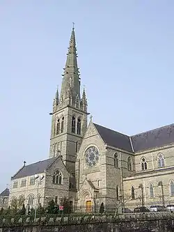 |
| 10 | Cathedral of Saint Patrick and Saint Felim | Cavan | Cavan | cathedral | 1942 | 70 m (230 ft)[3] |  |
| 11 | St Peter and St Paul Cathedral | Ennis | Clare | cathedral | 1874 | 69 m (226 ft) |  |
| 12 | Sacred Heart Church | Omagh | Tyrone | church | 1899 | 68.6 m (225 ft) |  |
| 13 | Church of Saints Augustine and John | Dublin | Dublin | church | 1874 | 68 m (223 ft) |  |
| 14 | St. Peter's Roman Catholic Church, Drogheda | Drogheda | Louth | church | 1884 | 67.66 m (222.0 ft) |  |
| 15 | St Columb's Cathedral | Derry | Londonderry | cathedral | 1633 | 67 m (220 ft) | %252C_August_2009.JPG.webp) |
| 16 | St Patrick's Cathedral (Church of Ireland) | Dublin | Dublin | cathedral | 1191 | 66 m (217 ft) |  |
| 17 | St Patrick's Cathedral (Roman Catholic) | Armagh | Armagh | cathedral | 1904 | 64 m (210 ft) |  |
| 18 | St Patrick's Church (Roman Catholic) | Belfast | Antrim | church | 1877 | 63 m (207 ft)[4] | .JPG.webp) |
| 19 | St George's Church | Dublin | Dublin | church | 1813 | 61 m (200 ft) |  |
| 20 | St. Marys Church of Ireland | Carlow | Carlow | church | 1834 | 59.5 m (195 ft)[5] |
Tallest structures
Other categories
Entries in the list that are in Northern Ireland are denoted by an asterisk, the others being in the Republic of Ireland.
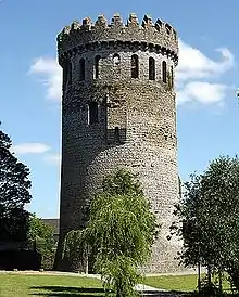
Nenagh Castle Keep
- Sculptures
- Spire of Dublin, 120 m (394 ft)
- Spire of Hope, St Anne’s Cathedral, Belfast*, 80m (262 ft)
- Gantry Cranes
- "Samson", Harland and Wolff, Belfast*, 106 m (348 ft)
- Bridges
- River Suir Bridge, Waterford, 100 m (330 ft)
- Boyne River Bridge, 95 m (312 ft)
- Windmills
- Kilgarvan Wind Farm (group of 14 wind turbines), 93 m (305 ft)
- Obelisks
- Wellington Monument, Phoenix Park, 63 m (207 ft) (Tallest in Europe)
- Lighthouses
- Fastnet Rock Lighthouse, 44.5 m (146 ft)
- Stadiums
- Croke Park, 40 m (131 ft)
- Air traffic control towers
- Dublin Airport ATC Tower, 86.9m
- Moving sculptures
- Irish Wave, Park West, Dublin, 35.4 m (116 ft) (Tallest in Europe)
- Round towers
- Kilmacduagh monastery, 34 m (112 ft)
- Castles
- Nenagh Castle Keep, 31 m (102 ft)
- Standing stones
- Punchestown, 6.5 m (21 ft)
- High crosses
- Muiredach's High Cross, Monasterboice, 6.45 m (21 ft)
Former
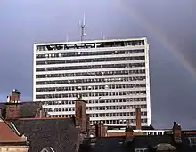
Former Churchill House, Belfast
- Tullamore transmitter, 290 m (952 ft), demolished 2023
- Clarkstown radio transmitter, 248 m (814 ft) demolished 2023
- Bellacorick Cooling Tower, 89 m (290 ft), demolished 2007
- Arrol Gantry, 70 m (228 ft), demolished 1969
- Churchill House, Belfast, 66 m (215 ft), demolished 2004
- Boyne Obelisk, 53 m (174 ft), destroyed 1923
- Ballymun Flats, 42 m (136 ft), demolished 2004-2015
- Nelson's Pillar Monument, 41 m (134 ft), destroyed 1966
- Walker's Monument, 32 m (105 ft) destroyed 1973
- Craigyhill Bonfire, 61 m (203 ft) destroyed 2022
See also
References
- ↑ "St John's Cathedral | Limerick.ie". www.limerick.ie. Retrieved 12 November 2020.
- ↑ "Belfast Cathedral". belfastcathedral.org.
- ↑ Cavan Cathedral - Kilmore Diocese
- ↑ "St Patrick's Church, Belfast". Emporis.com. Archived from the original on 29 June 2011. Retrieved 22 February 2011.
- ↑ "Carlow Town Walk". carlowtourism.com. Retrieved 2 October 2020.
- ↑ "Chimney of Kilroot power station". Emporis. Retrieved 12 September 2020.
- ↑ "Irish TV - over forty years of Irish TV History". Archived from the original on 19 May 2011. Retrieved 8 December 2010.
- ↑ "Irish TV - over forty years of Irish TV History". Archived from the original on 26 July 2011. Retrieved 8 December 2010.
- ↑ "Irish TV - Fifty years of Irish TV History". Archived from the original on 15 March 2012. Retrieved 6 November 2012.
- ↑ "Irish TV - over forty years of Irish TV History". Archived from the original on 26 July 2011. Retrieved 8 December 2010.
Other sources
- Tallest structures in Ireland
- Galloway, Peter; Cormac Simms (1992). The Cathedrals of Ireland. Dublin: Institute of Irish Studies. ISBN 0-85389-452-3.
- "Punchestown Standing Stone Standing Stone / Menhir – The Modern Antiquarian.com". Themodernantiquarian.com. 14 January 2006. Retrieved 13 June 2017.
- "Irish Wave". The Daily Telegraph. Archived from the original (XML) on 7 December 2003. Retrieved 13 June 2017.
- "Diagrams". SkyscraperPage.com. Retrieved 13 June 2017.
- "Dublin City Council". Dublincity.ie. Retrieved 13 June 2017.
This article is issued from Wikipedia. The text is licensed under Creative Commons - Attribution - Sharealike. Additional terms may apply for the media files.