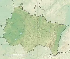
| Longeau | |
|---|---|
 | |
  | |
| Location | |
| Country | France |
| Physical characteristics | |
| Source | |
| • location | Hannonville-sous-les-Côtes |
| • coordinates | 49°01′16″N 5°38′10″E / 49.0212°N 5.636°E |
| Mouth | |
• location | Yron |
• coordinates | 49°08′52″N 5°51′28″E / 49.1477°N 5.8578°E |
| Length | 37.5 km (23.3 mi) |
| Basin size | 213 km2 (82 sq mi) |
| Basin features | |
| Progression | Yron→ Orne→ Moselle→ Rhine→ North Sea |
The Longeau is a 37.5-kilometre (23.3 mi) long river in the Grand Est of northeastern France.[1] It rises in Hannonville-sous-les-Côtes and runs generally northeast to join the river Yron at Jarny.
References
This article is issued from Wikipedia. The text is licensed under Creative Commons - Attribution - Sharealike. Additional terms may apply for the media files.