Lovell, Oklahoma | |
|---|---|
 Lovell  Lovell | |
| Coordinates: 36°03′22″N 97°38′11″W / 36.05611°N 97.63639°W | |
| Country | United States |
| State | Oklahoma |
| County | Logan |
| Area | |
| • Total | 0.11 sq mi (0.28 km2) |
| • Land | 0.11 sq mi (0.28 km2) |
| • Water | 0.00 sq mi (0.00 km2) |
| Elevation | 1,024 ft (312 m) |
| Population (2020) | |
| • Total | 28 |
| • Density | 264.15/sq mi (101.60/km2) |
| Time zone | UTC-6 (Central (CST)) |
| • Summer (DST) | UTC-5 (CDT) |
| ZIP Code | 73028 (Crescent) |
| Area code(s) | 405/572 |
| FIPS code | 40-44200 |
| GNIS feature ID | 2812855[2] |
Lovell is a census-designated place (CDP) in Logan County, Oklahoma, United States. It was first determined by the United States Census Bureau prior to the 2020 census.[2] It is named after the village of Lovell, which is incorporated in its boundaries.
The CDP is in northwestern Logan County, 3 miles (5 km) west of State Highway 74. It is 10 miles (16 km) northwest of Crescent and 24 miles (39 km) northwest of Guthrie.
Demographics
| Census | Pop. | Note | %± |
|---|---|---|---|
| 2020 | 28 | — | |
| U.S. Decennial Census[3] | |||
References
- ↑ "ArcGIS REST Services Directory". United States Census Bureau. Retrieved September 20, 2022.
- 1 2 3 U.S. Geological Survey Geographic Names Information System: Lovell, Oklahoma
- ↑ "Census of Population and Housing". Census.gov. Retrieved June 4, 2016.
Municipalities and communities of Logan County, Oklahoma, United States | ||
|---|---|---|
| Cities | 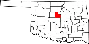 Logan County map | |
| Towns | ||
| CDPs | ||
| Other community | ||
| Footnotes | ‡This populated place also has portions in an adjacent county or counties | |
This article is issued from Wikipedia. The text is licensed under Creative Commons - Attribution - Sharealike. Additional terms may apply for the media files.