Lower Waterford, Vermont | |
|---|---|
Village | |
 Lower Waterford | |
| Coordinates: 44°21′16″N 71°54′25″W / 44.35444°N 71.90694°W | |
| Country | United States |
| State | Vermont |
| County | Caledonia |
| Elevation | 807 ft (246 m) |
| Time zone | UTC-5 (Eastern (EST)) |
| • Summer (DST) | UTC-4 (EDT) |
| ZIP code | 05848 |
| Area code | 802 |
| GNIS feature ID | 1458307[1] |
Lower Waterford is an unincorporated village in the town of Waterford, Caledonia County, Vermont, United States. The community is located along Vermont Route 18 7 miles (11 km) southeast of St. Johnsbury. Lower Waterford has a post office with ZIP code 05848, which opened on February 9, 1830.[2][3]
References
- ↑ "Lower Waterford". Geographic Names Information System. United States Geological Survey, United States Department of the Interior.
- ↑ United States Postal Service. "USPS - Look Up a ZIP Code". Retrieved May 22, 2017.
- ↑ "Postmaster Finder - Post Offices by ZIP Code". United States Postal Service. Retrieved May 22, 2017.
Municipalities and communities of Caledonia County, Vermont, United States | ||
|---|---|---|
| Towns | 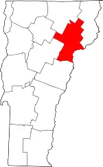 Map of Vermont highlighting Caledonia County | |
| Incorporated villages | ||
| CDPs | ||
| Unincorporated communities | ||
This article is issued from Wikipedia. The text is licensed under Creative Commons - Attribution - Sharealike. Additional terms may apply for the media files.