Malhador | |
|---|---|
 Flag  Coat of arms | |
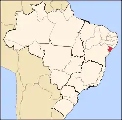
 Malhador Location in Brazil | |
| Coordinates: 10°39′28″S 37°18′18″W / 10.65778°S 37.30500°W | |
| Country | Brazil |
| Region | Northeast |
| State | Sergipe |
| Area | |
| • Total | 101 km2 (39 sq mi) |
| Population (2020 [1]) | |
| • Total | 12,653 |
| • Density | 130/km2 (320/sq mi) |
| Time zone | UTC−3 (BRT) |
Malhador is a municipality located in the Brazilian state of Sergipe. It is a little city in a rural area. It is located near Itabaiana. Its population was 12,653 (2020) and its area is 101 km².[2]
The municipality contains part of the Serra de Itabaiana National Park.[3]
References
Capital: Aracaju | |||||||||||||||
| Agreste Sergipano |
|  | |||||||||||||
| Leste Sergipano |
| ||||||||||||||
| Sertao Sergipano |
| ||||||||||||||
This article is issued from Wikipedia. The text is licensed under Creative Commons - Attribution - Sharealike. Additional terms may apply for the media files.