Matam Region
| |
|---|---|
 Location of Matam in Senegal | |
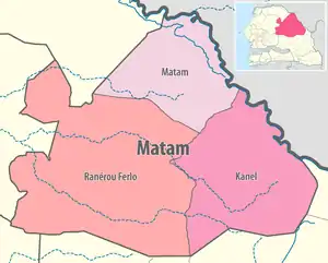 Matam région, divided into 3 départements | |
| Coordinates: 15°06′N 13°38′W / 15.100°N 13.633°W | |
| Country | Senegal |
| Capital | Matam |
| Départements | |
| Area | |
| • Total | 29,445 km2 (11,369 sq mi) |
| Population (2023 census) | |
| • Total | 833,657 |
| • Density | 28/km2 (73/sq mi) |
| Time zone | UTC+0 (GMT) |
Matam is a region of Senegal (regional capitals have the same name as their respective regions).
It is a stark, flat, arid place bounded on the north by the Sénégal River and the south by the Sahelian plain studded with baobab trees. Matam is populated by the tall Pulaar-speaking Toucouleur people who brought Islam to Senegal in the 11th century and gave us the music of Baaba Maal in the 21st century.
Departments
Matam region is divided into 3 departments:
Geography
Matam is traversed by the northwesterly line of equal latitude and longitude.
Cities and Villages
- Agnam-Goly
- Agnam Civol
- Bokidiawé
- Dabia
- Kanel
- Matam
- Nabadji Civol
- Ogo
- Oréfondé
- Orkadiére
- Ourossogui
- Ranérou
- Semme
- Sinthiou Bamambé
- Thilogne
- Vélingara
- Waoundé
- Diandioly
- Shinthiou Garba
- Fadiara
- Bokiladji
- Hadoubere
- Dembankane
- Yerimale
- Hamady Ounare
- Soringho
- Sinthiane
See also
External links
This article is issued from Wikipedia. The text is licensed under Creative Commons - Attribution - Sharealike. Additional terms may apply for the media files.