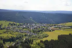
Meuselbach-Schwarzmühle | |
|---|---|
 | |
 Coat of arms | |
Location of Meuselbach-Schwarzmühle | |
 Meuselbach-Schwarzmühle 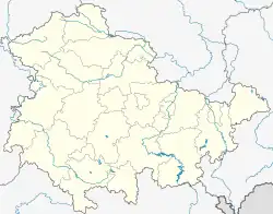 Meuselbach-Schwarzmühle | |
| Coordinates: 50°34′12″N 11°5′22″E / 50.57000°N 11.08944°E | |
| Country | Germany |
| State | Thuringia |
| District | Saalfeld-Rudolstadt |
| Town | Schwarzatal |
| Subdivisions | 2 |
| Area | |
| • Total | 7.50 km2 (2.90 sq mi) |
| Elevation | 560 m (1,840 ft) |
| Population (2017-12-31) | |
| • Total | 1,064 |
| • Density | 140/km2 (370/sq mi) |
| Time zone | UTC+01:00 (CET) |
| • Summer (DST) | UTC+02:00 (CEST) |
| Postal codes | 98746 |
| Dialling codes | 036705 |
| Website | www.meuselbach.de |
Meuselbach-Schwarzmühle is a village and a former municipality in the district Saalfeld-Rudolstadt, in Thuringia, Germany. Since 1 January 2019, it is part of the town Schwarzatal.[1]
References
This article is issued from Wikipedia. The text is licensed under Creative Commons - Attribution - Sharealike. Additional terms may apply for the media files.