| Moel y Cerrig Duon | |
|---|---|
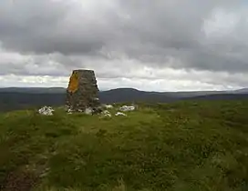 Moel y Cerrig Duon from Foel y Geifr summit | |
| Highest point | |
| Elevation | 625 m (2,051 ft) |
| Prominence | 80 m (260 ft) |
| Parent peak | Esgeiriau Gwynion |
| Listing | Hewitt, Nuttall |
| Naming | |
| English translation | bare hill of the black rocks |
| Language of name | Welsh |
| Geography | |
| Location | Gwynedd, Wales |
| Parent range | Aran Fawddwy |
| Topo map | OS Landranger 125 |
Moel y Cerrig Duon is a subsidiary summit of Esgeiriau Gwynion in Gwynedd in north Wales.
Moel y Cerrig Duon tops the eastern end of a long peat bog plateau along with Llechwedd Du. Its summit has a conical shape, rising suddenly from the bog. The summit itself is grassy, marked by a small cairn and a stake. To the north-east is Foel y Geifr, to the east Cyrniau Nod and to the west is Llechwedd Du, Esgeiriau Gwynion, and Aran Fawddwy.
Its otherwise unremarkable SW top Foel y Groes(582m) forms the watershed between the Dee, Severn and Dyfi catchments.
The Aran range continues south from Moel y Cerrig Duon forming a large area of high moorland to the west of Lake Vyrnwy, crowned by Mynydd Coch. To the north it continues to Foel y Geifr, the eastern outpost of the Aran Fawddwy range.[1]
References
52°52′48″N 3°22′55″W / 52.88011°N 3.38191°W