Montignac-de-Lauzun | |
|---|---|
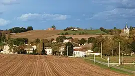 A general view of Montignac-de-Lauzun | |
Location of Montignac-de-Lauzun | |
 Montignac-de-Lauzun  Montignac-de-Lauzun | |
| Coordinates: 44°34′27″N 0°27′53″E / 44.5742°N 0.4647°E | |
| Country | France |
| Region | Nouvelle-Aquitaine |
| Department | Lot-et-Garonne |
| Arrondissement | Marmande |
| Canton | Le Val du Dropt |
| Intercommunality | CC Pays de Lauzun |
| Government | |
| • Mayor (2020–2026) | Jean-Marie Lenzi[1] |
| Area 1 | 20.46 km2 (7.90 sq mi) |
| Population | 286 |
| • Density | 14/km2 (36/sq mi) |
| Time zone | UTC+01:00 (CET) |
| • Summer (DST) | UTC+02:00 (CEST) |
| INSEE/Postal code | 47188 /47800 |
| Elevation | 61–147 m (200–482 ft) (avg. 190 m or 620 ft) |
| 1 French Land Register data, which excludes lakes, ponds, glaciers > 1 km2 (0.386 sq mi or 247 acres) and river estuaries. | |
Montignac-de-Lauzun (French pronunciation: [mɔ̃tiɲak də lozœ̃], literally Montignac of Lauzun; Occitan: Montinhac de Lausun) is a commune in the Lot-et-Garonne department in south-western France.
See also
References
- ↑ "Répertoire national des élus: les maires" (in French). data.gouv.fr, Plateforme ouverte des données publiques françaises. 13 September 2022.
- ↑ "Populations légales 2021". The National Institute of Statistics and Economic Studies. 28 December 2023.
Wikimedia Commons has media related to Montignac-de-Lauzun.
This article is issued from Wikipedia. The text is licensed under Creative Commons - Attribution - Sharealike. Additional terms may apply for the media files.