Monts-de-Randon | |
|---|---|
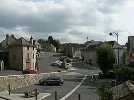 The church square, in Rieutort-de-Randon | |
Location of Monts-de-Randon | |
 Monts-de-Randon  Monts-de-Randon | |
| Coordinates: 44°38′07″N 3°28′45″E / 44.6353°N 3.4792°E | |
| Country | France |
| Region | Occitania |
| Department | Lozère |
| Arrondissement | Mende |
| Canton | Saint-Alban-sur-Limagnole |
| Intercommunality | Randon-Margeride |
| Government | |
| • Mayor (2020–2026) | Francis Saint-Léger[1] |
| Area 1 | 147.38 km2 (56.90 sq mi) |
| Population | 1,236 |
| • Density | 8.4/km2 (22/sq mi) |
| Time zone | UTC+01:00 (CET) |
| • Summer (DST) | UTC+02:00 (CEST) |
| INSEE/Postal code | 48127 /48700 |
| Elevation | 840–1,550 m (2,760–5,090 ft) |
| 1 French Land Register data, which excludes lakes, ponds, glaciers > 1 km2 (0.386 sq mi or 247 acres) and river estuaries. | |
Monts-de-Randon (French pronunciation: [mɔ̃ də ʁɑ̃dɔ̃]) is a commune in the Lozère department in southern France. It was established on 1 January 2019 by merger of the former communes of Rieutort-de-Randon (the seat), Estables, Saint-Amans, Servières and La Villedieu.[3]
See also
References
- ↑ "Répertoire national des élus: les maires" (in French). data.gouv.fr, Plateforme ouverte des données publiques françaises. 6 June 2023.
- ↑ "Populations légales 2021". The National Institute of Statistics and Economic Studies. 28 December 2023.
- ↑ Arrêté préfectoral 28 November 2018 (in French)
Wikimedia Commons has media related to Monts-de-Randon.
This article is issued from Wikipedia. The text is licensed under Creative Commons - Attribution - Sharealike. Additional terms may apply for the media files.