Mukh Kampul
ស្រុកមុខកំពូល | |
|---|---|
 Mukh Kampul Location in Cambodia | |
| Coordinates: 11°44′32″N 104°58′51″E / 11.74222°N 104.98083°E | |
| Country | |
| Province | Kandal |
| Communes | 7 |
| Villages | 39 |
| Population (1998)[1] | |
| • Total | 77,456 |
| Time zone | UTC+7 (ICT) |
| Geocode | 0807 |
Mukh Kampul (Khmer: ស្រុកមុខកំពូល) is a district (srok) of Kandal Province, Cambodia. The district is subdivided into 9 communes (khum) such as Bak Khaeng, Kaoh Dach, Preaek Anhchanh, Preaek Dambang, Roka Kaong Muoy, Roka Kaong Pir, Ruessei Chrouy, Sambuor Meas, Svay Ampear and 47 villages (phum).[2]
References
- ↑ General Population Census of Cambodia, 1998: Village Gazetteer. National Institute of Statistics. February 2000. pp. 149–152.
- ↑ "Kandal Administration". Royal Government of Cambodia. Archived from the original on 2008-12-24. Retrieved 2009-02-01.
External links
Capital: Ta Khmau | ||
| Municipality | 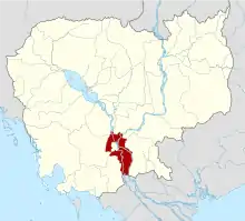 | |
| Districts | ||
| Autonomous municipality |
| ||
|---|---|---|---|
| Provinces | |||
11°44′32″N 104°58′51″E / 11.74222°N 104.98083°E
This article is issued from Wikipedia. The text is licensed under Creative Commons - Attribution - Sharealike. Additional terms may apply for the media files.