Municipality of Kupres
Općina Kupres | |
|---|---|
 Flag  Coat of arms | |
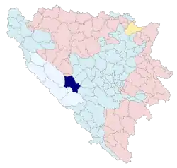 Location of the Municipality of Kupres within Bosnia and Herzegovina | |
| Country | Bosnia and Herzegovina |
| Entity | Federation of Bosnia and Herzegovina |
| Canton | Canton 10 |
| Seat | Kupres |
| Government | |
| • Municipal president | Zdravko Mioč (HDZ BiH) |
| Area | |
| • Total | 569.8 km2 (220.0 sq mi) |
| Population (2013) | |
| • Total | 5,057 |
| • Density | 8.9/km2 (23/sq mi) |
| Demonym | Kupresan |
| Website | opcinakupres |
Municipality of Kupres (Croatian: Općina Kupres) is a municipality in Canton 10 of the Federation of Bosnia and Herzegovina, an entity of Bosnia and Herzegovina. Its seat is in Kupres. According to the 2013 census, it had a population of 5,057.
Demographics
According to the 2013 census, the population of Kupres was 5,057.[1]
| Settlement | Nationality | Total | ||||||||
|---|---|---|---|---|---|---|---|---|---|---|
| Croats | % | Serbs | % | Bosniaks | % | Others | % | |||
| Bajramovci | 0 | 0 | 12 | 100 | 0 | 0 | 0 | 0 | 12 | |
| Begovo Selo | 161 | 98.77 | 2 | 1.23 | 0 | 0 | 0 | 0 | 163 | |
| Bili Potok | 36 | 100 | 0 | 0 | 0 | 0 | 0 | 0 | 36 | |
| Blagaj | 0 | 0 | 48 | 100 | 0 | 0 | 0 | 0 | 48 | |
| Botun | 23 | 85.19 | 0 | 0 | 4 | 14.81 | 0 | 0 | 27 | |
| Brda | 0 | 0 | 0 | 0 | 10 | 100 | 0 | 0 | 10 | |
| Bućovača | 0 | 0 | 23 | 100 | 0 | 0 | 0 | 0 | 23 | |
| Donje Ravno | 0 | 0 | 43 | 58.90 | 30 | 41.10 | 0 | 0 | 73 | |
| Donje Vukovsko | 0 | 0 | 7 | 100 | 0 | 0 | 0 | 0 | 7 | |
| Donji Malovan | 1 | 1.82 | 54 | 98.18 | 0 | 0 | 0 | 0 | 55 | |
| Goravci | 140 | 92.11 | 0 | 0 | 12 | 7.89 | 0 | 0 | 152 | |
| Gornje Ravno | 0 | 0 | 27 | 100 | 0 | 0 | 0 | 0 | 27 | |
| Gornje Vukovsko | 0 | 0 | 1 | 100 | 0 | 0 | 0 | 0 | 1 | |
| Gornji Malovan | 12 | 37.50 | 30 | 62.50 | 0 | 0 | 0 | 0 | 42 | |
| Kudilji | 0 | 0 | 0 | 0 | 0 | 0 | 0 | 0 | 0 | |
| Kukavice | 0 | 0 | 0 | 0 | 11 | 100 | 0 | 0 | 11 | |
| Kupres | 2,737 | 94.94 | 23 | 0.80 | 116 | 4.02 | 7 | 0.24 | 2,883 | |
| Kute | 0 | 0 | 0 | 0 | 51 | 100 | 0 | 0 | 51 | |
| Mlakva | 0 | 0 | 0 | 0 | 0 | 0 | 0 | 0 | 0 | |
| Mrđanovci | 0 | 0 | 13 | 100 | 0 | 0 | 0 | 0 | 13 | |
| Mrđebare | 0 | 0 | 0 | 0 | 0 | 0 | 0 | 0 | 0 | |
| Mušić | 0 | 0 | 23 | 100 | 0 | 0 | 0 | 0 | 23 | |
| Novo Selo | 0 | 0 | 0 | 0 | 0 | 0 | 0 | 0 | 0 | |
| Odžak | 215 | 95.13 | 0 | 0 | 9 | 3.98 | 2 | 0.88 | 226 | |
| Olovo | 78 | 100 | 0 | 0 | 0 | 0 | 0 | 0 | 78 | |
| Osmanlije | 375 | 100 | 0 | 0 | 0 | 0 | 0 | 0 | 375 | |
| Otinovci | 142 | 94.67 | 0 | 0 | 7 | 4.67 | 1 | 0.67 | 150 | |
| Rastičevo | 5 | 50.00 | 5 | 50.00 | 0 | 0 | 0 | 0 | 10 | |
| Rilić | 0 | 0 | 12 | 70.59 | 5 | 29.41 | 0 | 0 | 17 | |
| Šemenovci | 0 | 0 | 13 | 100 | 0 | 0 | 0 | 0 | 13 | |
| Stražbenica | 15 | 100 | 0 | 0 | 0 | 0 | 0 | 0 | 15 | |
| Suhova | 2 | 100 | 0 | 0 | 0 | 0 | 0 | 0 | 2 | |
| Vrila | 0 | 0 | 0 | 0 | 0 | 0 | 0 | 0 | 0 | |
| Zanaglina | 0 | 0 | 0 | 0 | 0 | 0 | 0 | 0 | 0 | |
| Zlosela | 392 | 100 | 0 | 0 | 0 | 0 | 0 | 0 | 392 | |
| Zvirnjača | 132 | 100 | 0 | 0 | 0 | 0 | 0 | 0 | 132 | |
| Municipality | 4,474 | 88.47 | 318 | 6.29 | 255 | 5.04 | 10 | 0.20 | 5,057 | |
| Reference: [2] | ||||||||||
Footnotes
Bibliography
- Ethnicity/National Affiliation, Religion and Mother Tongue (PDF). Sarajevo: Agency for Statistics of Bosnia and Herzegovina. 2019.
This article is issued from Wikipedia. The text is licensed under Creative Commons - Attribution - Sharealike. Additional terms may apply for the media files.