North Branch, Kansas | |
|---|---|
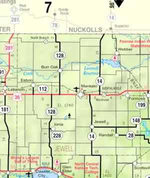 KDOT map of Jewell County (legend) | |
 North Branch  North Branch | |
| Coordinates: 39°58′22″N 98°22′18″W / 39.97278°N 98.37167°W[1] | |
| Country | United States |
| State | Kansas |
| County | Jewell |
| Elevation | 1,870 ft (570 m) |
| Time zone | UTC-6 (CST) |
| • Summer (DST) | UTC-5 (CDT) |
| Area code | 785 |
| FIPS code | 20-51075 |
| GNIS ID | 482708 [1] |
North Branch is an unincorporated community in Jewell County, Kansas, United States.[1] It is located 2 miles south of the Nebraska/Kansas state line at the intersection of Cedar Rd and 78 Rd.
History
Also known as Northbranch. North Branch had a post office from the 1870s until 1959.[2]
Education
The community is served by Rock Hills USD 107 public school district.
References
- 1 2 3 4 "North Branch, Kansas", Geographic Names Information System, United States Geological Survey, United States Department of the Interior
- ↑ "Kansas Post Offices, 1828-1961". Kansas Historical Society. Retrieved June 11, 2014.
Further reading
External links
Municipalities and communities of Jewell County, Kansas, United States | ||
|---|---|---|
| Cities | 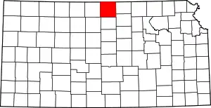 Map of Kansas highlighting Jewell County | |
| Unincorporated communities | ||
| Ghost towns | ||
| Townships | ||
| Footnotes | †This community is designated a Census-Designated Place (CDP) by the United States Census Bureau. | |
This article is issued from Wikipedia. The text is licensed under Creative Commons - Attribution - Sharealike. Additional terms may apply for the media files.