| Ognon | |
|---|---|
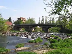 The Ognon near Lure | |
 | |
| Location | |
| Country | France |
| Physical characteristics | |
| Source | |
| • location | Vosges Mountains |
| • elevation | ±900 m (3,000 ft) |
| Mouth | |
• location | Saône |
• coordinates | 47°18′51″N 5°26′4″E / 47.31417°N 5.43444°E |
| Length | 214 km (133 mi) |
| Basin size | 2,308 km2 (891 sq mi) |
| Discharge | |
| • average | 36 m3/s (1,300 cu ft/s) |
| Basin features | |
| Progression | Saône→ Rhône→ Mediterranean Sea |
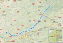
The Ognon (French pronunciation: [ɔɲɔ̃] ⓘ) is a river of Eastern France. It is a left tributary of the Saône, which it joins in Pontailler-sur-Saône. Its source is in Haut-du-Them-Château-Lambert in the Vosges Mountains near the Ballon d'Alsace. Its length is 214 km (133 mi)[1] and its basin area is 2,308 km2 (891 sq mi).
The Ognon flows through the following departments and towns: Haute-Saône, with Mélisey, Lure, Villersexel, Pesmes; Doubs, with Rougemont; Jura; Côte-d'Or, with Pontailler-sur-Saône.
Tributaries
Some of its tributaries include:
- The Rahin
- The Scey
- The Reigne
- The Buthiers
References
External links
Wikimedia Commons has media related to Ognon (Franche-Comté).
This article is issued from Wikipedia. The text is licensed under Creative Commons - Attribution - Sharealike. Additional terms may apply for the media files.