State Highway 72 | ||||
|---|---|---|---|---|
 | ||||
| Route information | ||||
| Maintained by ODOT | ||||
| Length | 32.9 mi (52.9 km) | |||
| Major junctions | ||||
| South end | ||||
| North end | ||||
| Location | ||||
| Country | United States | |||
| State | Oklahoma | |||
| Highway system | ||||
| ||||
| ||||

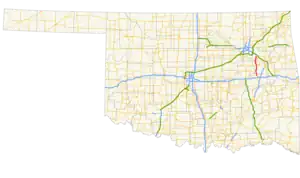
State Highway 72 (abbreviated SH-72 or OK-72) is a state highway in the U.S. state of Oklahoma. It runs from north to south through the east-central part of the state, with a length of almost 33 miles (53 km). It does not have any lettered spur routes.
Route description
SH-72 begins at U.S. Highway 266 west of Checotah[1] and heads north, passing through Council Hill after 4 miles (6.4 km).[2] Two miles south of Boynton, it meets US-62, with which it starts a duplex. Past Boynton, the concurrent routes have a junction with US-64 and SH-16; here, US-62 splits off of SH-72 and US-64 joins it.
Near Haskell, US-64 splits off SH-72, headed towards Tulsa. SH-72 continues northward to cross the Arkansas River, to Coweta.[3]
History
The clearance below the railroad underpass in downtown Coweta near the junction with SH-51 was previously only 13 ft (4.0 m). Between February 2009 and April 2010, the crossing was rehabilitated and expanded, with the clearance increased to 17 ft 1 in (5.21 m).[4]
Junction list
| County | Location | mi | km | Destinations | Notes |
|---|---|---|---|---|---|
| McIntosh | | 0.0 | 0.0 | Southern terminus | |
| Muskogee | | 7.7 | 12.4 | ||
| Jamesville | 16.8 | 27.0 | |||
| 16.8 | 27.0 | ||||
| 16.8 | 27.0 | ||||
| Haskell | 22.7 | 36.5 | |||
| 23.1 | 37.2 | ||||
| Wagoner | Coweta | 32.1 | 51.7 | ||
| 32.9 | 52.9 | Northern terminus | |||
1.000 mi = 1.609 km; 1.000 km = 0.621 mi
| |||||
References
- ↑ Control Section Maps (PDF) (Map). Oklahoma Department of Transportation. March 2018. § 46: McIntosh County. Retrieved October 21, 2022.
- ↑ Control Section Maps (PDF) (Map). Oklahoma Department of Transportation. March 2018. § 51: Muskogee County. Retrieved October 21, 2022.
- ↑ Control Section Maps (PDF) (Map). Oklahoma Department of Transportation. March 2018. § 73: Wagoner County. Retrieved October 21, 2022.
- ↑ Howell, Chris (April 19, 2010). "Highway 72 Underpass Opening to Help with Traffic, Safety and Growth in Coweta". Newson6.com. Retrieved October 21, 2022.