Olešnice v Orlických horách | |
|---|---|
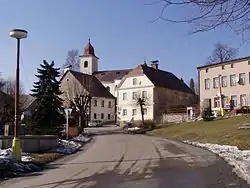 Centre of Olešnice v Orlických horách | |
 Flag  Coat of arms | |
 Olešnice v Orlických horách Location in the Czech Republic | |
| Coordinates: 50°22′23″N 16°18′36″E / 50.37306°N 16.31000°E | |
| Country | |
| Region | Hradec Králové |
| District | Rychnov nad Kněžnou |
| First mentioned | 1369 |
| Area | |
| • Total | 14.30 km2 (5.52 sq mi) |
| Elevation | 593 m (1,946 ft) |
| Population (2023-01-01)[1] | |
| • Total | 391 |
| • Density | 27/km2 (71/sq mi) |
| Time zone | UTC+1 (CET) |
| • Summer (DST) | UTC+2 (CEST) |
| Postal code | 517 83 |
| Website | www |
Olešnice v Orlických horách is a municipality and village in Rychnov nad Kněžnou District in the Hradec Králové Region of the Czech Republic. It has about 400 inhabitants.
References
Wikimedia Commons has media related to Olešnice v Orlických horách.
This article is issued from Wikipedia. The text is licensed under Creative Commons - Attribution - Sharealike. Additional terms may apply for the media files.