On Top of the World | |
|---|---|
 On Top of the World  On Top of the World | |
| Coordinates: 29°6′24″N 82°17′6″W / 29.10667°N 82.28500°W | |
| Country | |
| State | Florida |
| County | Marion |
| Area | |
| • Total | 17.51 sq mi (45.34 km2) |
| • Land | 17.51 sq mi (45.34 km2) |
| • Water | 0.00 sq mi (0.00 km2) |
| Elevation | 71 ft (22 m) |
| Population | |
| • Total | 12,668 |
| • Density | 723.64/sq mi (279.40/km2) |
| Time zone | UTC-5 (Eastern (EST)) |
| • Summer (DST) | UTC-4 (EDT) |
| ZIP Codes | |
| Area code | 352 |
| FIPS code | 12-51587 |
| GNIS feature ID | 2805184[2] |
On Top of the World is a census-designated place (CDP) in southwestern Marion County, Florida, United States. It is 11 miles (18 km) southwest of Ocala, the county seat.
On Top of the World was first listed as a CDP for the 2020 census, when it had a population of 12,668.[3]
Demographics
| Census | Pop. | Note | %± |
|---|---|---|---|
| 2020 | 12,668 | — | |
| U.S. Decennial Census[4] | |||
References
- ↑ "2022 U.S. Gazetteer Files: Florida". United States Census Bureau. Retrieved December 19, 2022.
- 1 2 "On Top of the World Census Designated Place". Geographic Names Information System. United States Geological Survey, United States Department of the Interior.
- 1 2 "P1. Race – On Top of the World CDP, Florida: 2020 DEC Redistricting Data (PL 94-171)". U.S. Census Bureau. Retrieved December 19, 2022.
- ↑ "Census of Population and Housing". Census.gov. Retrieved June 4, 2016.
Municipalities and communities of Marion County, Florida, United States | ||
|---|---|---|
| Cities | 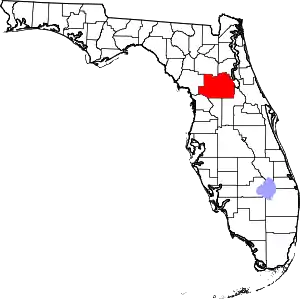 | |
| Towns | ||
| CDPs | ||
| Unincorporated communities | ||
| Footnotes | ‡This populated place also has portions in an adjacent county or counties | |
This article is issued from Wikipedia. The text is licensed under Creative Commons - Attribution - Sharealike. Additional terms may apply for the media files.