 | ||||
|---|---|---|---|---|
| European Motorway Avrupa Otoyolu | ||||
 | ||||
| Route information | ||||
| Part of | ||||
| Part of | ||||
| Length | 245 km (152 mi) | |||
| Existed | 1987–present | |||
| Major junctions | ||||
| West end | ||||
| East end | ||||
| Location | ||||
| Country | Turkey | |||
| Regions | Marmara | |||
| Provinces | Edirne, Kırklareli, Tekirdağ, Istanbul | |||
| Major cities | Edirne, Istanbul | |||
| Highway system | ||||
| ||||
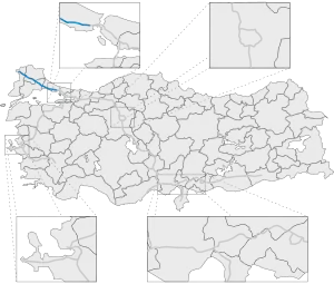
Otoyol 3 (English: Motorway 3), also known as the European Motorway (Turkish: Avrupa Otoyolu) and abbreviated as the O-3 is a 245.1 km (152.3 mi) long otoyol in East Thrace, Turkey. The O-3 runs from Edirne to Istanbul and is the only motorway in Turkey located entirely in Europe. The motorway begins west of Edirne at a junction with the ![]() D.100 where it then continues as a beltway passing just north of Edirne. From there, the motorway passes through mostly rural farmland until it enters the Istanbul metropolis near Silivri. The eastern end of the O-3 is at the interchange with the
D.100 where it then continues as a beltway passing just north of Edirne. From there, the motorway passes through mostly rural farmland until it enters the Istanbul metropolis near Silivri. The eastern end of the O-3 is at the interchange with the ![]() O-1, where the motorway becomes Vatan Caddesi and continues into the historic peninsula of Istanbul as a major boulevard.
O-1, where the motorway becomes Vatan Caddesi and continues into the historic peninsula of Istanbul as a major boulevard.
The O-3 connects with three other motorways, all in Istanbul; the O-1, ![]() O-2 and the
O-2 and the ![]() O-7; and is a part of the
O-7; and is a part of the ![]() E80, the International E-road network and
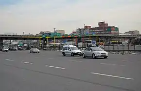
E80, the International E-road network and ![]() AH1 of the Asian Highway Network. The motorway has six lanes, three in each direction, except for a 44.6 km (27.7 mi) section between Silivri and Esenyurt.
AH1 of the Asian Highway Network. The motorway has six lanes, three in each direction, except for a 44.6 km (27.7 mi) section between Silivri and Esenyurt.
Exit list
| Province | District | km | mi | Exit | Destination | Notes | |
|---|---|---|---|---|---|---|---|
| Edirne | Edirne Merkez | 0 | 0 | K1 | Westbound only | ||
| 11.5 | 7.1 | K2 | |||||
| 15.8 | 9.8 | K3 | |||||
| 16.7 | 10.3 | Edirne Toll Plaza | |||||
| Havsa | 35.7 | 22.1 | K4 | ||||
| Kırklareli | Babaeski | 62.9 | 39 | K5 | |||
| Lüleburgaz | 87.3 | 54.2 | K6 | ||||
| Tekirdağ | Saray | 116.1 | 72.1 | K7 | P.59-01 — Vakıflar, Saray | ||
| Çorlu | 136.3 | 84.6 | K8 | P.59-04 — Çorlu, Velimeşe | |||
| Istanbul | Silivri | 154.8 | 96.1 | K9 | |||
| 167.1 | 103.8 | K10 | connector to | ||||
| 174.3 | 108.3 | K11 | TEM connector — Silivri | ||||
| 186.1 | 115.6 | K12 | Selimpaşa connector — Selimpaşa | ||||
| Büyükçekmece | 193.6 | 120.2 | K13 | Kumburgaz connector — Kumburgaz | |||
| 199.6 | 124 | K14 | |||||
| Esenyurt | 211.7 | 131.5 | K15 | ||||
| 223.8 | 139 | K16 | Avcılar-H.dere connector — Esenyurt | ||||
| Avcılar | 226.8 | 140.9 | K17 | Ispartakule Blv. — Avcılar | |||
| Küçükçekmece/Başakşehir | 234.5 | 145.7 | Mahmutbey Toll Plaza | ||||
| Bağcılar | 235.7 | 146.4 | K18 | connector to the | |||
| 236.8 | 147.1 | - | Köprü Cd. | Eastbound exit and entrance only | |||
| 237.3 | 147.4 | - | Northern Service Rd. | Westbound exit only | |||
| 237.8 | 147.7 | - | Mahmutbey Rd. | Westbound exit only | |||
| 238.4 | 148.1 | K19 | |||||
| 238.7 | 148.3 | - | Hüseyin Karaaslan Cd. | Eastbound exit and entrance, westbound entrance | |||
| 239.5 | 148.8 | - | Matbaacılar Cd. / South Service Rd. | Eastbound entrance, westbound exit | |||
| Esenler | 240.6 | 149.5 | - | Köyiçi Cd. | Eastbound exit, westbound exit | ||
| 240.9 | 149.6 | - | Karaoğlanoğlu Cd. | Westbound entrance | |||
| 241.6 | 150.1 | - | Mehmt Akif Ersoy Cd. | Eastbound entrance | |||
| 241.8 | 150.2 | - | Atışalanı Cd. | Westbound exit | |||
| 242.4 | 150.6 | K20 | Metris-Esenler connector | ||||
| Bayrampaşa | 243.8 | 151.4 | - | 50. Yıl Cd. | Westbound exit | ||
| 244.7 | 152 | - | Ulus Sk. | Eastbound entrance | |||
| 245 | 152.2 | - | Abdi İpekçi Cd. | ||||
| 246.4 | 153.1 | - | |||||
| 246.9 | 153.4 | - | Adnan Menderes Blv. — Fatih | Transition into Boulevard | |||
| 1.000 mi = 1.609 km; 1.000 km = 0.621 mi | |||||||
See also
References
- Turkish General Directorate of Highways. Turkey road map. 2009.
External links
| Current | ||
|---|---|---|
| Former | ||
| Planned |
| |
| ||