Palisades, Washington | |
|---|---|
 Palisades | |
| Coordinates: 47°25′08″N 119°54′52″W / 47.41889°N 119.91444°W | |
| Country | United States |
| State | Washington |
| County | Douglas |
| Elevation | 981 ft (299 m) |
| Time zone | UTC-8 (Pacific (PST)) |
| • Summer (DST) | UTC-7 (PDT) |
| ZIP code | 98845 |
| Area code | 509 |
| GNIS feature ID | 1531057[1] |
Palisades is an unincorporated community in Douglas County, Washington, United States. Palisades is 17.5 miles (28.2 km) east of East Wenatchee. Palisades has a post office with ZIP code 98845.[2]
A post office called Palisades was established in 1908.[3] The community was named for a nearby rock formation.[4]
References
- ↑ U.S. Geological Survey Geographic Names Information System: Palisades, Washington
- ↑ ZIP Code Lookup
- ↑ "Post Offices". Jim Forte Postal History. Retrieved August 22, 2016.
- ↑ Meany, Edmond S. (1923). Origin of Washington geographic names. Seattle: University of Washington Press. p. 206.
Municipalities and communities of Douglas County, Washington, United States | ||
|---|---|---|
| Cities | 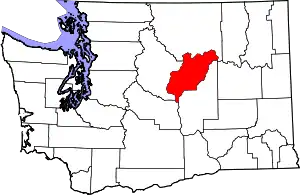 Map of Washington highlighting Douglas County | |
| Towns | ||
| Unincorporated communities | ||
| Ghost towns | ||
| Footnotes | ‡This populated place also has portions in an adjacent county or counties | |
| ||
This article is issued from Wikipedia. The text is licensed under Creative Commons - Attribution - Sharealike. Additional terms may apply for the media files.