| Park Cone | |
|---|---|
 Park Cone | |
| Highest point | |
| Elevation | 12,106 ft (3,690 m)[1][2] |
| Prominence | 2,040 ft (622 m)[2] |
| Isolation | 3.44 mi (5.54 km)[2] |
| Listing | Colorado prominent summits |
| Coordinates | 38°47′48″N 106°36′11″W / 38.7966605°N 106.6030863°W[3] |
| Geography | |
 Park Cone | |
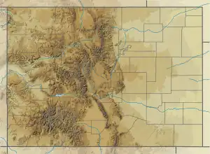
| Location | Gunnison County, Colorado, U.S.[3] |
| Parent range | Sawatch Range |
| Topo map | USGS 7.5' topographic map Taylor Park Reservoir, Colorado[3] |
Park Cone, elevation 12,106 ft (3,690 m), is a summit in the Sawatch Range of central Colorado. The mountain is northeast of Gunnison in the Gunnison National Forest.
See also
References
- ↑ The elevation of Park Cone includes an adjustment of +1.873 m (+6.15 ft) from NGVD 29 to NAVD 88.
- 1 2 3 "Park Cone, Colorado". Peakbagger.com. Retrieved October 21, 2014.
- 1 2 3 "Park Cone". Geographic Names Information System. United States Geological Survey, United States Department of the Interior. Retrieved October 21, 2014.
External links
Denver (capital) | |
| Topics |
|
| Society | |
| Cities |
|
| Counties |
|
| Regions |
|
| Federal |
| ||||||||||||||||||||||||||||||||
|---|---|---|---|---|---|---|---|---|---|---|---|---|---|---|---|---|---|---|---|---|---|---|---|---|---|---|---|---|---|---|---|---|---|
| State |
| ||||||||||||||||||||||||||||||||
| Trails |
| ||||||||||||||||||||||||||||||||
This article is issued from Wikipedia. The text is licensed under Creative Commons - Attribution - Sharealike. Additional terms may apply for the media files.