Peru, Pennsylvania | |
|---|---|
 Peru | |
| Coordinates: 40°51′17″N 77°46′00″W / 40.85472°N 77.76667°W | |
| Country | United States |
| State | Pennsylvania |
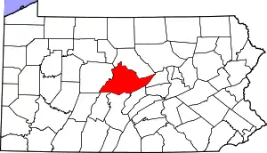
| County | Centre |
| Township | Benner |
| Area | |
| • Total | 0.03 sq mi (0.09 km2) |
| • Land | 0.03 sq mi (0.09 km2) |
| • Water | 0.00 sq mi (0.00 km2) |
| Population | |
| • Total | 26 |
| • Density | 787.88/sq mi (300.97/km2) |
| Demonym | Peruvian |
| Time zone | Eastern (EST) |
| • Summer (DST) | EDT |
| Area code | 814 |
| FIPS code | 42-59580 |
Peru is an unincorporated community in Benner Township, Centre County, Pennsylvania, United States.[3] Peru is alternatively known unofficially as Lauvertown.[4] Peru is located northeast of State College and southwest of Pleasant Gap along Pennsylvania Route 26 near the Pennsylvania State Correctional Institution at Rockview.
Demographics
| Census | Pop. | Note | %± |
|---|---|---|---|
| 2020 | 26 | — | |
| U.S. Decennial Census[5] | |||
References
- ↑ "ArcGIS REST Services Directory". United States Census Bureau. Retrieved October 16, 2022.
- ↑ "Census Population API". United States Census Bureau. Retrieved October 16, 2022.
- ↑ "Peru, Pennsylvania". Placenames.com. Archived from the original on June 11, 2010. Retrieved July 26, 2009.
- ↑ "Peru, PA Community Profile". PA HomeTownLocator. Retrieved August 2, 2009.
- ↑ "Census of Population and Housing". Census.gov. Retrieved June 4, 2016.
40°51′17″N 77°46′01″W / 40.85472°N 77.76694°W
This article is issued from Wikipedia. The text is licensed under Creative Commons - Attribution - Sharealike. Additional terms may apply for the media files.