Pinckard, Kentucky | |
|---|---|
 Pinckard, Kentucky | |
| Coordinates: 37°58′38″N 84°40′54″W / 37.97722°N 84.68167°W | |
| Country | United States |
| State | Kentucky |
| County | Woodford |
| Elevation | 817 ft (249 m) |
| Time zone | UTC-6 (Central (CST)) |
| • Summer (DST) | UTC-5 (CDT) |
| Area code | 859 |
| GNIS feature ID | 500660[1] |
Pinckard is an unincorporated community in Woodford County, Kentucky, United States. Pinckard is located on Kentucky Route 169 southwest of Lexington and south of Versailles.
References
- ↑ "US Board on Geographic Names". United States Geological Survey. October 25, 2007. Retrieved January 31, 2008.
Municipalities and communities of Woodford County, Kentucky, United States | ||
|---|---|---|
| Cities | 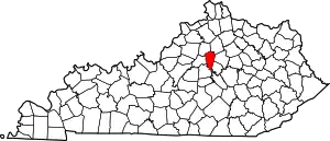 Location of Woodford County, Kentucky | |
| Unincorporated communities | ||
| Ghost town | ||
This article is issued from Wikipedia. The text is licensed under Creative Commons - Attribution - Sharealike. Additional terms may apply for the media files.