Pine Air, Florida | |
|---|---|
 Pine Air, Florida | |
| Coordinates: 26°39′32″N 80°06′26″W / 26.65889°N 80.10722°W | |
| Country | |
| State | |
| County | |
| Area | |
| • Total | 0.31 sq mi (0.80 km2) |
| • Land | 0.31 sq mi (0.80 km2) |
| • Water | 0.00 sq mi (0.00 km2) |
| Elevation | 16 ft (5 m) |
| Population (2020) | |
| • Total | 2,190 |
| • Density | 7,064.52/sq mi (2,730.08/km2) |
| Time zone | UTC-5 (Eastern (EST)) |
| • Summer (DST) | UTC-4 (EDT) |
| ZIP code | 33406[2] |
| Area code(s) | 561, 728 |
| GNIS feature ID | 2628530[3] |
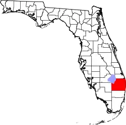
Pine Air is a census-designated place (CDP) in Palm Beach County, Florida, United States. It is a part of the Miami metropolitan area of South Florida. The population was 2,190 as of the 2020 census.
Geography
Pine Air is located at 26°39′32″N 80°06′26″W / 26.65889°N 80.10722°W.[4]
It is bordered by Military Trail (State Road 809) to the west and the village of Palm Springs to the south.
Demographics
| Census | Pop. | Note | %± |
|---|---|---|---|
| 2010 | 2,024 | — | |
| 2020 | 2,190 | 8.2% | |
| U.S. Decennial Census[5] | |||
2020 census
| Race | Number | Percentage |
|---|---|---|
| White (NH) | 400 | 18.26% |
| Black or African American (NH) | 154 | 7.03% |
| Native American or Alaska Native (NH) | 6 | 0.27% |
| Asian (NH) | 38 | 1.74% |
| Pacific Islander or Native Hawaiian (NH) | 0 | 0.00% |
| Some Other Race (NH) | 14 | 0.64% |
| Mixed/Multiracial (NH) | 36 | 1.64% |
| Hispanic or Latino | 1,542 | 70.41% |
| Total | 2,190 |
As of the 2020 United States census, there were 2,190 people, 626 households, and 425 families residing in the CDP.[7]
2010 census
| Race | Number | Percentage |
|---|---|---|
| White (NH) | 584 | 28.85% |
| Black or African American (NH) | 145 | 7.16% |
| Native American or Alaska Native (NH) | 1 | 0.05% |
| Asian (NH) | 30 | 1.48% |
| Pacific Islander or Native Hawaiian (NH) | 0 | 0.00% |
| Some Other Race (NH) | 5 | 0.25% |
| Mixed/Multiracial (NH) | 8 | 0.40% |
| Hispanic or Latino | 1,251 | 61.80% |
| Total | 2,024 |
As of the 2010 United States census, there were 2,024 people, 672 households, and 503 families residing in the CDP.[9]
References
- ↑ "2020 U.S. Gazetteer Files". United States Census Bureau. Retrieved October 31, 2021.
- ↑ "Pine Air FL ZIP Code". zipdatamaps.com. 2023. Retrieved February 17, 2023.
- ↑ "Pine Air Census Designated Place". Geographic Names Information System. United States Geological Survey, United States Department of the Interior.
- ↑ "US Gazetteer files: 2020, 2010, 2000, and 1990". United States Census Bureau. July 26, 2023.
- ↑ "Census of Population and Housing". Census.gov. Retrieved June 4, 2016.
- ↑ "HISPANIC OR LATINO, AND NOT HISPANIC OR LATINO BY RACE: 2020". data.census.gov. Retrieved July 26, 2023.
- ↑ "HOUSEHOLDS AND FAMILIES: 2020". data.census.gov. Retrieved July 26, 2023.
- ↑ "HISPANIC OR LATINO, AND NOT HISPANIC OR LATINO BY RACE: 2010". data.census.gov. Retrieved July 26, 2023.
- ↑ "HOUSEHOLDS AND FAMILIES: 2010". data.census.gov. Retrieved July 26, 2023.
This article is issued from Wikipedia. The text is licensed under Creative Commons - Attribution - Sharealike. Additional terms may apply for the media files.