Reynolds Heights, Pennsylvania | |
|---|---|
| Country | United States |
| State | Pennsylvania |
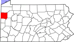
| County | Mercer |
| Area | |
| • Total | 2.91 sq mi (7.53 km2) |
| • Land | 2.90 sq mi (7.52 km2) |
| • Water | 0.01 sq mi (0.01 km2) |
| Population | |
| • Total | 1,974 |
| • Density | 679.75/sq mi (262.49/km2) |
| Time zone | UTC-5 (Eastern (EST)) |
| • Summer (DST) | UTC-4 (EDT) |
| FIPS code | 42-64368 |
Reynolds Heights is a census-designated place[3] located in Pymatuning Township and in Mercer County in the state of Pennsylvania. The community is located off Pennsylvania Route 18. As of the 2010 census[4] the population was 2,061 residents, which fell to 1,974 inhabitants at the 2020 Census. It is part of the Hermitage micropolitan area.
Demographics
| Census | Pop. | Note | %± |
|---|---|---|---|
| 2020 | 1,974 | — | |
| U.S. Decennial Census[5] | |||
References
- ↑ "ArcGIS REST Services Directory". United States Census Bureau. Retrieved August 8, 2023.
- ↑ "Census Population API". United States Census Bureau. Retrieved August 8, 2023.
- ↑ "By Decade".
- ↑ https://www.census.gov/#
- ↑ "Census of Population and Housing". Census.gov. Retrieved June 4, 2016.
This article is issued from Wikipedia. The text is licensed under Creative Commons - Attribution - Sharealike. Additional terms may apply for the media files.