Ricardo, Texas | |
|---|---|
 Ricardo  Ricardo | |
| Coordinates: 27°25′17″N 97°51′04″W / 27.42139°N 97.85111°W | |
| Country | United States |
| State | Texas |
| County | Kleberg |
| Area | |
| • Total | 4.46 sq mi (11.56 km2) |
| • Land | 4.46 sq mi (11.56 km2) |
| • Water | 0.0 sq mi (0.0 km2) |
| Elevation | 53 ft (16 m) |
| Population (2010) | |
| • Total | 1,048 |
| • Density | 235/sq mi (90.7/km2) |
| Time zone | UTC-6 (Central (CST)) |
| • Summer (DST) | UTC-5 (CDT) |
| ZIP code | 78363 |
| Area code | 361 |
| FIPS code | 48-61724 |
| GNIS feature ID | 1375725[1] |
Ricardo is a small census-designated place in Kleberg County, Texas, United States. As of the 2010 census it had a population of 1,048.[2]
Located on U.S. Highway 77 between Kingsville and Riviera, it consists of a farmers co-op, a convenience store, and an elementary/junior high school. The school's mascot is a Yellow Jacket. Since there is no high school, students either attend Kaufer High School in Riviera, Academy High School in Kingsville, or Henrietta M. King High School in Kingsville.[3]
See also
References
- ↑ "Ricardo". Geographic Names Information System. United States Geological Survey, United States Department of the Interior.
- ↑ "Geographic Identifiers: 2010 Census Summary File 1 (G001), Ricardo CDP, Texas". American FactFinder. U.S. Census Bureau. Archived from the original on February 13, 2020. Retrieved May 10, 2019.
- ↑ O., COALSON, GEORGE (June 15, 2010). "RICARDO, TX". tshaonline.org. Retrieved May 5, 2017.
{{cite web}}: CS1 maint: multiple names: authors list (link)
Municipalities and communities of Kleberg County, Texas, United States | ||
|---|---|---|
| Cities | 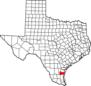 Kleberg County map | |
| CDPs | ||
| Other community | ||
| Footnotes | ‡This populated place also has portions in an adjacent county or counties | |
This article is issued from Wikipedia. The text is licensed under Creative Commons - Attribution - Sharealike. Additional terms may apply for the media files.