Sé | |
|---|---|
 Sé Location in Portugal | |
| Coordinates: 41°48′40″N 6°45′58″W / 41.811°N 6.766°W | |
| Country | |
| Region | Norte |
| Intermunic. comm. | Terras de Trás-os-Montes |
| District | Bragança |
| Municipality | Bragança |
| Disbanded | 2013 |
| Area | |
| • Total | 10.72 km2 (4.14 sq mi) |
| Population (2001) | |
| • Total | 17,913 |
| • Density | 1,700/km2 (4,300/sq mi) |
| Time zone | UTC±00:00 (WET) |
| • Summer (DST) | UTC+01:00 (WEST) |
| Website | http://www.braganca-se.com.pt/ |
Sé is a former civil parish in the municipality of Bragança, Portugal. In 2013, the parish merged into the new parish Sé, Santa Maria e Meixedo.[1] The population in 2011 was 17,913,[2] in an area of 10.72 km2.[3]
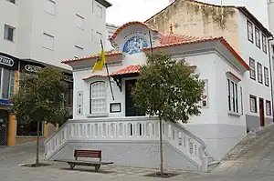
Old building of the Junta de Freguesia.
Heritage
- Bragança Castle
- Pelourinho de Bragança
- Domus Municipalis
- Bragança Regional Hospital and Mental Health Center
- Igreja Paroquial de São João Baptista or Igreja da Sé or Igreja dos Jesuítas
References
- ↑ Diário da República. "Law nr. 11-A/2013, pages 552 28-29" (PDF) (in Portuguese). Retrieved 4 July 2014.
- ↑ Instituto Nacional de Estatística
- ↑ Eurostat
This article is issued from Wikipedia. The text is licensed under Creative Commons - Attribution - Sharealike. Additional terms may apply for the media files.