Saint-Alexis-de-Matapédia | |
|---|---|
 | |
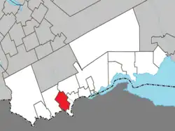 Location within Avignon RCM. | |
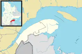 Saint-Alexis-de-Matapédia Location in eastern Quebec. | |
| Coordinates: 47°58′N 67°03′W / 47.967°N 67.050°W[1] | |
| Country | |
| Province | |
| Region | Gaspésie– Îles-de-la-Madeleine |
| RCM | Avignon |
| Constituted | July 1, 1855 |
| Government | |
| • Mayor | Guy Gallant |
| • Federal riding | Gaspésie— Îles-de-la-Madeleine |
| • Prov. riding | Bonaventure |
| Area | |
| • Total | 85.40 km2 (32.97 sq mi) |
| • Land | 84.40 km2 (32.59 sq mi) |
| Population (2011)[3] | |
| • Total | 548 |
| • Density | 6.5/km2 (17/sq mi) |
| • Pop 2006–2011 | |
| • Dwellings | 286 |
| Time zone | UTC−5 (EST) |
| • Summer (DST) | UTC−4 (EDT) |
| Postal code(s) | |
| Area code(s) | 418 and 581 |
| Highways | No major routes |
| Website | www.matapedia lesplateaux.com |
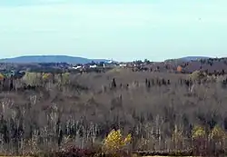
Saint-Alexis-de-Matapédia is a village and municipality in the Gaspésie–Îles-de-la-Madeleine region of eastern Quebec, Canada.
In addition to Saint-Alexis-de-Matapédia itself, the municipality also includes the communities of Léonard-de-Matapédia and Saint-Benoît-de-Matapédia.
In 2003, the Parish Municipality of Saint-Alexis-de-Matapédia became the Municipality of Saint-Alexis-de-Matapédia.
History
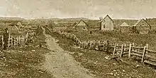
Saint-Alexis-de-Matapédia ca. 1895
Demographics
Population
Canada census – Saint-Alexis-de-Matapédia community profile
| 2021 | 2011 | |
|---|---|---|
| Population | 519 (+3.8% from 2016) | 548 (-12.3% from 2006) |
| Land area | 84.91 km2 (32.78 sq mi) | 84.40 km2 (32.59 sq mi) |
| Population density | 6.1/km2 (16/sq mi) | 6.5/km2 (17/sq mi) |
| Median age | 58.8 (M: 56.8, F: 61.2) | 54.3 (M: 52.5, F: 57.1) |
| Private dwellings | 250 (total) | 286 (total) |
| Median household income | $34,713 |
|
|
|
See also
References
- ↑ "Banque de noms de lieux du Québec: Reference number 380542". toponymie.gouv.qc.ca (in French). Commission de toponymie du Québec.
- 1 2 "Saint-Alexis-de-Matapédia". Répertoire des municipalités (in French). Ministère des Affaires municipales, des Régions et de l'Occupation du territoire. Retrieved 2012-01-12.
- 1 2 3 "2011 Community Profiles". 2011 Canadian Census. Statistics Canada. March 21, 2019. Retrieved 2014-01-29.
- ↑ "2021 Community Profiles". 2021 Canadian Census. Statistics Canada. February 4, 2022. Retrieved 2022-04-27.
- ↑ "2006 Community Profiles". 2006 Canadian Census. Statistics Canada. August 20, 2019.
- ↑ "2001 Community Profiles". 2001 Canadian Census. Statistics Canada. July 18, 2021.
- ↑ Statistics Canada: 1996, 2001, 2006, 2011 census
External links
Adjacent Municipal Subdivisions | ||||||||||||||||
|---|---|---|---|---|---|---|---|---|---|---|---|---|---|---|---|---|
| ||||||||||||||||
| Cities & Towns | |
|---|---|
| Municipalities | |
| Townships | |
| Unorganized Territories | |
| |
This article is issued from Wikipedia. The text is licensed under Creative Commons - Attribution - Sharealike. Additional terms may apply for the media files.