Saint-Jean-des-Échelles | |
|---|---|
Location of Saint-Jean-des-Échelles | |
 Saint-Jean-des-Échelles  Saint-Jean-des-Échelles | |
| Coordinates: 48°07′47″N 0°42′47″E / 48.1297°N 0.7131°E | |
| Country | France |
| Region | Pays de la Loire |
| Department | Sarthe |
| Arrondissement | Mamers |
| Canton | Saint-Calais |
| Intercommunality | Pays de l'Huisne Sarthoise |
| Government | |
| • Mayor (2020–2026) | Yves Goullier[1] |
| Area 1 | 10.64 km2 (4.11 sq mi) |
| Population | 227 |
| • Density | 21/km2 (55/sq mi) |
| Time zone | UTC+01:00 (CET) |
| • Summer (DST) | UTC+02:00 (CEST) |
| INSEE/Postal code | 72292 /72320 |
| Elevation | 104–200 m (341–656 ft) |
| 1 French Land Register data, which excludes lakes, ponds, glaciers > 1 km2 (0.386 sq mi or 247 acres) and river estuaries. | |
Saint-Jean-des-Échelles (French pronunciation: [sɛ̃ ʒɑ̃ de.z‿eʃɛl]) is a commune in the Sarthe department in the region of Pays de la Loire in north-western France.
There are two notable buildings in Saint-Jean-des-Échelles. The parish church of Saint-Jean-Baptiste dates from the 12ht century. It contains ten bas-reliefs from the 16th century,and three altars and altarpieces from the 18th century. The whole is listed as a historical monument. Secondly, Courtangis Castle forms part of the locality.
Gallery
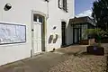 The townhall.
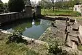 Unusual communal Lavoir or clothes washing place.
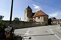 Parish church with rounded body and square tower
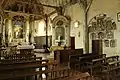 Interior of parish church
See also
References
- ↑ "Répertoire national des élus: les maires". data.gouv.fr, Plateforme ouverte des données publiques françaises (in French). 2 December 2020.
- ↑ "Populations légales 2021". The National Institute of Statistics and Economic Studies. 28 December 2023.
Wikimedia Commons has media related to Saint-Jean-des-Échelles.
This article is issued from Wikipedia. The text is licensed under Creative Commons - Attribution - Sharealike. Additional terms may apply for the media files.