Sandgap, Kentucky | |
|---|---|
 The community's post office | |
 Sandgap  Sandgap | |
| Coordinates: 37°29′10″N 84°05′26″W / 37.48611°N 84.09056°W | |
| Country | United States |
| State | Kentucky |
| County | Jackson |
| Elevation | 1,453 ft (443 m) |
| Time zone | UTC-5 (Eastern (EST)) |
| • Summer (DST) | UTC-4 (EDT) |
| ZIP codes | 40481 |
| Area code | 606 |
| GNIS feature ID | 515235[1] |
Sandgap is a small, unincorporated community in northwestern Jackson County, KY. It is located along U.S. Route 421, at its junction with KY Route 2004. Sandgap Elementary School (K-5) is located in the community and is operated by the Jackson County Public School system.[2] The community offers a few services such as a post office, grocery store, and gas station.[3]
References
- ↑ "Sandgap". Geographic Names Information System. United States Geological Survey, United States Department of the Interior.
- ↑ "Schools". Jackson County Public Schools. Retrieved August 1, 2022.
- ↑ "Hospitality". Jackson County Kentucky Tourism. Retrieved August 1, 2022.
Municipalities and communities of Jackson County, Kentucky, United States | ||
|---|---|---|
| City | 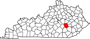 Location of Jackson County, Kentucky | |
| CDP | ||
| Unincorporated communities | ||
| post offices (and the creeks they are on) |
| |
| Ghost towns | ||
This article is issued from Wikipedia. The text is licensed under Creative Commons - Attribution - Sharealike. Additional terms may apply for the media files.