Sankt Andrä-Höch | |
|---|---|
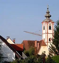 Sankt Andrä-Höch parish church | |
 Coat of arms | |
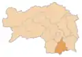
 Sankt Andrä-Höch Location within Austria | |
| Coordinates: 46°47′33″N 15°22′46″E / 46.79250°N 15.37944°E | |
| Country | Austria |
| State | Styria |
| District | Leibnitz |
| Government | |
| • Mayor | Rudolf Stiendl (ÖVP) |
| Area | |
| • Total | 20.62 km2 (7.96 sq mi) |
| Elevation | 318 - 671 m (−1,883 ft) |
| Population (2018-01-01)[2] | |
| • Total | 1,731 |
| • Density | 84/km2 (220/sq mi) |
| Time zone | UTC+1 (CET) |
| • Summer (DST) | UTC+2 (CEST) |
| Postal code | 8444, 8441, 8442, 8443, 8505, 8521, 8522 |
| Area code | 03456, 03457, 03185 |
| Vehicle registration | LB |
| Website | www.st-andrae-hoech.at |
Sankt Andrä-Höch is a municipality in the district of Leibnitz in the Austrian state of Styria.
Geography
Sankt Andrä-Höch lies about 35 km south of Graz and about 15 km west of Leibnitz.
References
- ↑ "Dauersiedlungsraum der Gemeinden Politischen Bezirke und Bundesländer - Gebietsstand 1.1.2018". Statistics Austria. Retrieved 10 March 2019.
- ↑ "Einwohnerzahl 1.1.2018 nach Gemeinden mit Status, Gebietsstand 1.1.2018". Statistics Austria. Retrieved 9 March 2019.
This article is issued from Wikipedia. The text is licensed under Creative Commons - Attribution - Sharealike. Additional terms may apply for the media files.