Sankt Marein bei Knittelfeld | |
|---|---|
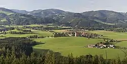 Remte view of Sankt Marein | |
 Coat of arms | |
 Sankt Marein bei Knittelfeld Location within Austria | |
| Coordinates: 47°16′16″N 14°51′38″E / 47.27111°N 14.86056°E | |
| Country | Austria |
| State | Styria |
| District | Murtal |
| Government | |
| • Mayor | Wolfgang Kuhelnik (SPÖ) |
| Area | |
| • Total | 60.64 km2 (23.41 sq mi) |
| Elevation | 698 m (2,290 ft) |
| Population (1 January 2016)[1] | |
| • Total | 1,245 |
| • Density | 21/km2 (53/sq mi) |
| Time zone | UTC+1 (CET) |
| • Summer (DST) | UTC+2 (CEST) |
| Postal code | 8733 |
| Area code | 03515 |
| Vehicle registration | KF |
| Website | www.st-marein-knittelfeld. steiermark.at |
Sankt Marein bei Knittelfeld is a former municipality in the district of Murtal in Styria, Austria. Since the 2015 Styria municipal structural reform, it is part of the municipality Sankt Marein-Feistritz.[2]
References
- ↑ Statistik Austria - Bevölkerung zu Jahresbeginn 2002-2016 nach Gemeinden (Gebietsstand 1.1.2016) for Sankt Marein bei Knittelfeld.
- ↑ Die neue Gemeindestruktur der Steiermark
This article is issued from Wikipedia. The text is licensed under Creative Commons - Attribution - Sharealike. Additional terms may apply for the media files.